-
Tours
-
-
- Domestic Tours
-
-
- Resorts
- Car Rentals
- Destinations
- Getaways
- Hotels
- Tools
- * Workation
- * Tour Plans
- Blog
- List Property
- * Offers *


At a distance of 53 km from Ella, 72 km from Kandy, 182 km from Sigiriya, 150 km from Dambulla, 168 km from Colombo, 188 km from Polonnaruwa, 227 km from Anuradhapura, 230 km from Mirissa, 267 km from Galle, 274 km from Trincomalee, and 412 km from Jaffna, Nuwara Eliya is a beautiful hill town in the central highlands of Sri Lanka. It is the administrative capital of Nuwara Eliya district and among the must-include places in Sri Lanka Packages.
Often called the mini London, Nuwara Eliya is known for its picturesque landscape and temperate climate. The literal meaning of Nuwara Eliya is the 'city on the plain (table land)' or 'city of lights'. It is a perfect place to relax and escape the oppressive heat and humidity that surrounds the rest of the country as this is the highest town in Sri Lanka situated at an altitude of 1868 m. Overlooked by Pidurutalagala, the tallest mountain in Sri Lanka, Nuwara Eliya is considered to be the most important location for tea production in Sri Lanka.
Though Nuwara Eliya had been inhabited during the early period of the kingdom of Kandy, the existence of the spectacular 'Eliya' valley wasn't known to the Colonial British until the accidental discovery by the colonial civil servant John Davy in the year 1819. Governor Edward Barnes converted Nuwara Eliya into a commercial and a coffee planting center during the 1830s. In the year 1847, the great colonial explorer Samuel Baker ...
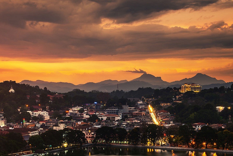
At a distance of 72 km from Nuwara Eliya, 92 km from Sigiriya, 110 km from Dambulla, 116 km from Colombo, 129 km from Ella, 137 km from Polonnaruwa, 140 km from Anuradhapura, 183 km from Trincomalee, 223 km from Galle, 245 km from Mirissa, and 321 km from Jaffna, Kandy is a scenic city located in central Sri Lanka. It is the capital of the Central Province of Sri Lanka and among the must-include places in Sri Lanka Tour Packages.
Set on a high plateau in the midst of the thick tropical forests and the tea plantations is the city of Kandy, the second-largest city in Sri Lanka. More popularly known as the hill capital of Sri Lanka, Kandy is known for its spirituality and laid-back charm due to which the colonial town is frequented by tourists as well as Buddhists, especially of the Theravada School. The well-planned town of Kandy added value to its legacy and never changed its roots for the sake of development. It was declared a world heritage site by UNESCO in the year 1988.
The city and the region have been known by many different names and versions of those names. Some scholars suggest that the original name of Kandy was Katubulu Nuwara. However, the more popular historical name is Senkadagala or Senkadagalapura, officially Senkadagala Siriwardhana Maha Nuwara, generally shortened to 'Maha Nuwara'. The name Kandy is derived from an Anglicized version of the Sinhala Kanda Uda Rata, meaning the land on the mountain ...
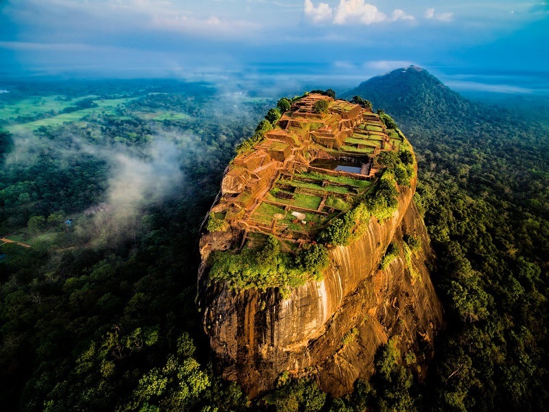
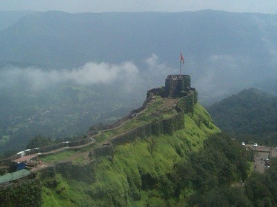
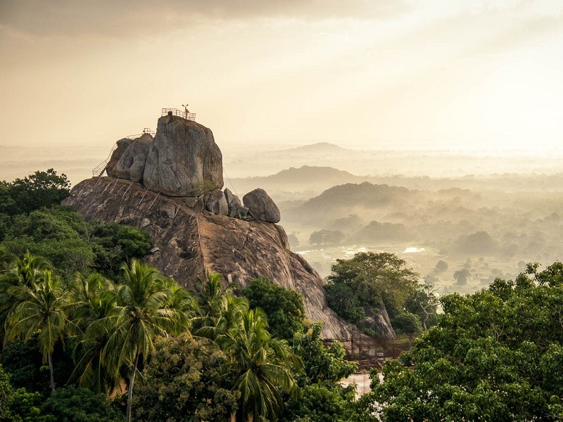
At a distance of 16 km from Dambulla, 62 km from Polonnaruwa, 75 km from Anuradhapura, 90 km from Kandy, 100 km from Trincomalee, 176 km from Colombo and 181 km from Nuwara Eliya, Sigiriya is an ancient city in the northern Matale district of Central Province in Sri Lanka. It is probably the most visited tourist destination of Sri Lanka as part of Sri Lanka Tour Packages.
Sigiriya sits right in the middle of Sri Lanka's Cultural Triangle made up of Kandy, Anuradhapura, and Polonnaruwa. Also known as the Lion's Rock or Lion Mountain, Sigiriya is a popular stop for tourists who are interested in archeological ruins as it is home to the ruins of the world recognized ancient Sigiriya Rock Fortress situated on top of a massive 200-meter high rock surrounded by the remains of an extensive network of gardens, reservoirs, and other structures. The rock itself is a lava plug left over from an ancient long extinct volcano.
Excavations at Sigiriya indicate that the area was occupied during the prehistoric times. There is clear evidence that the many rock shelters and caves in the vicinity were occupied by Buddhist monks and ascetics from as early as the 3rd century BCE. In 477 CE, King Kashyapa of Anuradhapura moved the capital from the traditional capital of Anuradhapura to the more secure Sigiriya. During Kashyapa's reign (477 to 495 CE), Sigiriya was developed into a complex city and fortress. After his death, the site fell into decline and was again used as a Buddhist monastery ...
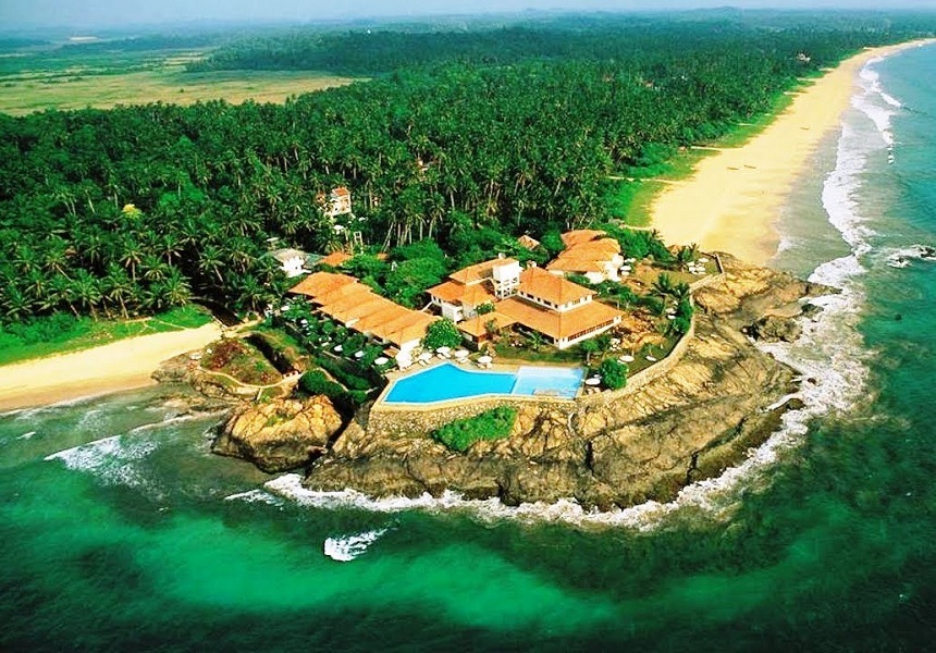
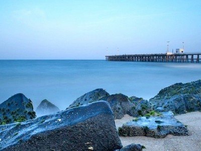
At a distance of 55 km from Galle, 89 km from Mirissa, 104 km from Colombo, 180 km from Kandy, 195 km from Ella, 209 km from Nuwara Eliya, 231 km from Sigiriya and 262 km from Anuradhapura, Bentota is a coastal town in Galle district of Southern Province in Sri Lanka. Known for its sandy shores, it is one of the popular beaches to visit in the island country as part of Sri Lanka Tour.
Located on the southern bank of the Bentota River, Bentota is a quaint town surrounded by sandy shores, pristine waters and lush green landscapes with the dominance of tall palm trees. Interestingly, the name 'Bentota' is derived from Ben, a demon who once ruled the Tota or river bank. It is considered to be the prime beach resort of Sri Lanka as the National Holiday Resort Complex is associated with the Bentota Beach.
The place is known for its sun-kissed beaches, lagoon, dive sites that offer the best views of coral reefs, century-old Buddhist temples, gardens and long stretches of coconut trees. Its glorious sun-kissed beaches make the town a perfect destination for families to spend quality time on the beach. Bentota Beach, Brief Garden, Moragalla Beach, Cinnamon Island, Kande Vihare Temple, Galapata Vihara, and Madu Ganga River Safari are the top places to visit in Bentota. Bentota is home to the majestic marine turtles. The community-run hatcheries in the area are doing their bit to help propagate marine life.
Bentota ...
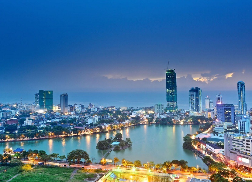
At a distance of 39 km from Negambo, 116 km from Kandy, 126 km from Galle, 150 km from Mirissa, 161 km from Dambulla, 167 km from Nuwara Eliya, 202 km from Anuradhapura, 205 km from Ella, 230 km from Polonnaruwa and 395 km from Jaffna, Colombo is the commercial capital and the largest city of Sri Lanka by population. Located in the western province of the Island, it is one of the must-include places in Sri Lanka Tour Packages.
With rich colonial heritage and very scenic and popular attractions, Colombo is arguably the most popular tourist destination in Sri Lanka. Sri Jayawardenepura Kotte, the legislative capital of the country, is within the urban area of the city, hence Colombo is often called the capital of Sri Lanka as well. It is also the administrative capital of the Western Province and the capital of Colombo district. The name 'Colombo', is believed to be derived from the classical Sinhala name Kolon Thota, meaning 'port on the river Kelani'. Another belief is that the name is derived from the Sinhala name Kola-amba-thota which means 'Harbour with leafy/green mango trees'.
Sri Lanka has a long history and so does Colombo. As far back as the 5th century AD, Colombo served as a seaport for trade between Asia and the West. During the 8th century, Arab traders settled near the port. The Portuguese arrived in 1505 CE and later by the mid-17th century the Dutch had taken over Colombo and used as the capital ...
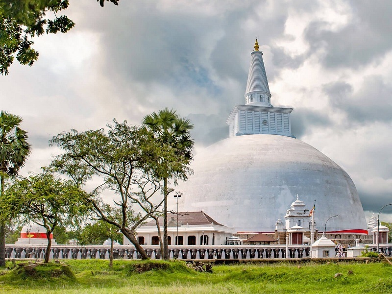
At a distance of 66 km from Dambulla, 75 km from Sigiriya, 106 km from Trincomalee, 107 km from Polonnaruwa, 139 km from Kandy, 194 km from Jaffna and 202 km from Colombo, Anuradhapura is an ancient city in Sri Lanka. It is the capital city of North Central Province and also the capital of Anuradhapura district. It is the most popular heritage place in Sri Lanka and among the must include destinations in Sri Lanka Tour Packages.
Located on the banks of Malvathu River, Anuradhapura is the first ancient capital of Sri Lanka. The city was the center of Theravada Buddhism for many centuries. Famous for its well-preserved ruins of an ancient Sinhala civilization, Anuradhapura is one of the oldest continuously inhabited cities in the world and one of the eight World Heritage Sites of Sri Lanka. The city is also home to one of the largest and most sacred Bodhi trees in Sri Lanka, believed to be a descendant of the original Bodhi tree where Buddha got enlightenment.
Anuradhapura was first established by Anuradha, a follower of Prince Vijaya, the founder of the Sinhala race. Later in 377 BC, King Pandukabhaya made it his capital and developed it into a prosperous city. It was the royal capital for 119 successive Singhalese Kings and lasted for about 1500 years. Anuradhapura came into prominence after Buddhism was introduced to the island in the 3rd Century BC during the reign of King Devanampiya Tissa.
Anuradhapura ...
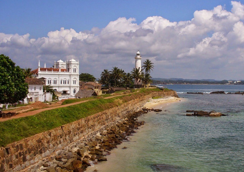
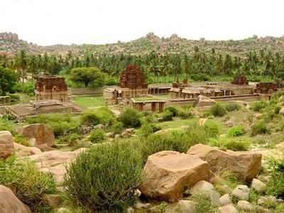
At a distance of 42 km from Matara, 55 km from Bentota, 126 km from Colombo, 190 km from Yala, 222 km from Kandy, 251 km from Nuwara Eliya, 304 km from Anuradhapura, and 365 km from Trincomalee, Galle is an ancient port city located on the southwestern tip of Sri Lanka. It is one of the most popular tourist attractions to visit in the region as part of Sri Lanka Tour Packages and among the must include places to visit in honeymoon trip.
Synonymous with the country's fascinating history and rich culture, no Sri Lanka Tour is complete without visiting Galle as this historic city is blessed with imposing Dutch-colonial buildings, ancient mosques, and churches, grand mansions, and museums. Galle was known as Gimhathitha in ancient times and is believed to be derived from the classical Sinhalese term meaning 'port near the river Gin'. Another theory is that the word Galle is derived from the Dutch word 'Gallus', which means rooster, as the Dutch have used the rooster as a symbol of Galle.
As per the historical records, Galle was an important trading center for the Arabs, Chinese and Malays, long before the Europeans occupied it. The colonial period began with the arrival of the Portuguese in the 16th century, who was on the way to the Maldives. They remained here and built a fort called Santa Cruz. Later, the Dutch invaded Galle and began the reconstruction of ...
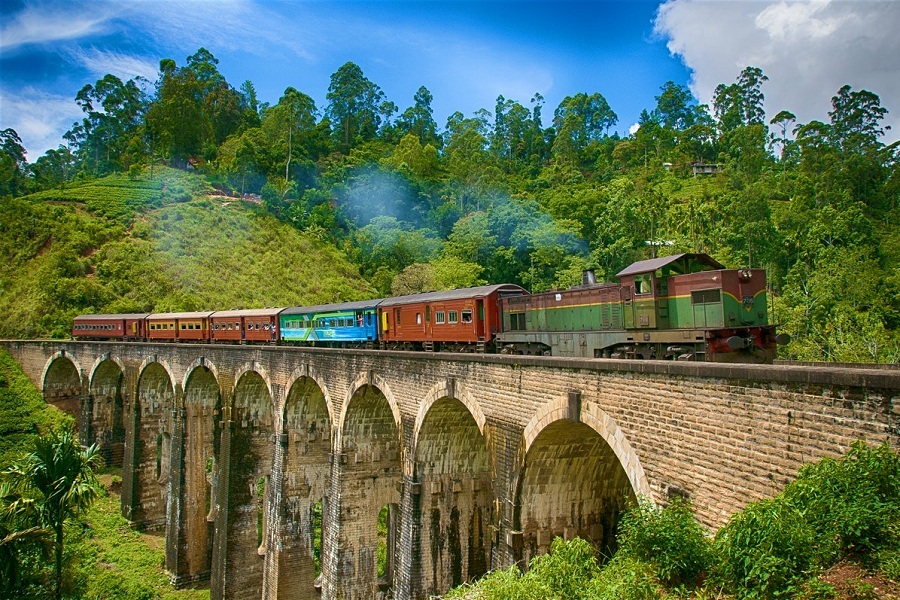
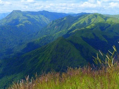
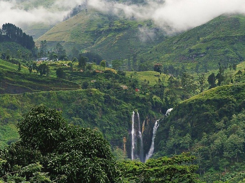
At a distance of 22 km from Badulla, 53 km from Nuwara Eliya, 129 km from Kandy, 166 km from Polonnaruwa, 171 km from Dambulla, 182 km from Sigiriya, 221 km from Galle, 224 km from Colombo, 235 km from Anuradhapura, 272 km from Trincomalee, and 415 km from Jaffna, Ella is a quaint little hill town located in the Badulla district of the Uva Province in Sri Lanka. It is regarded as one of the most beautiful places to visit on the island as part of Sri Lanka Tour Packages.
Situated at an altitude of 3,415 feet, Ella is surrounded by hills covered with cloud forests and tea plantations. The area has a rich bio-diversity, dense with numerous varieties of flora and fauna. The town also offers stunning mountain hikes and lovely waterfalls. With picture-perfect environs, a pleasant climate, and super-friendly people, it is an ideal destination for people trying to break the routine of the warm and humid climate of coastal Sri Lanka. The town is most famous for its iconic nine arches railway bridge which is a fine example of colonial-era construction in Sri Lanka.
The hill town of Ella is connected to the Hindu epic, Ramayana, a historic tale that covers over India and Sri Lanka. The locals believed that the town of Ella is the place where goddess Sita was held captive in a cave near Ravana Falls. The story goes that King Ravana kidnapped Princess Sita from India and hid her in the caves behind the waterfall. It is also ...
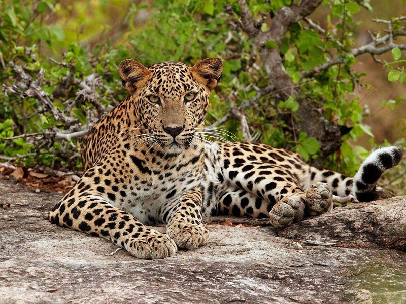
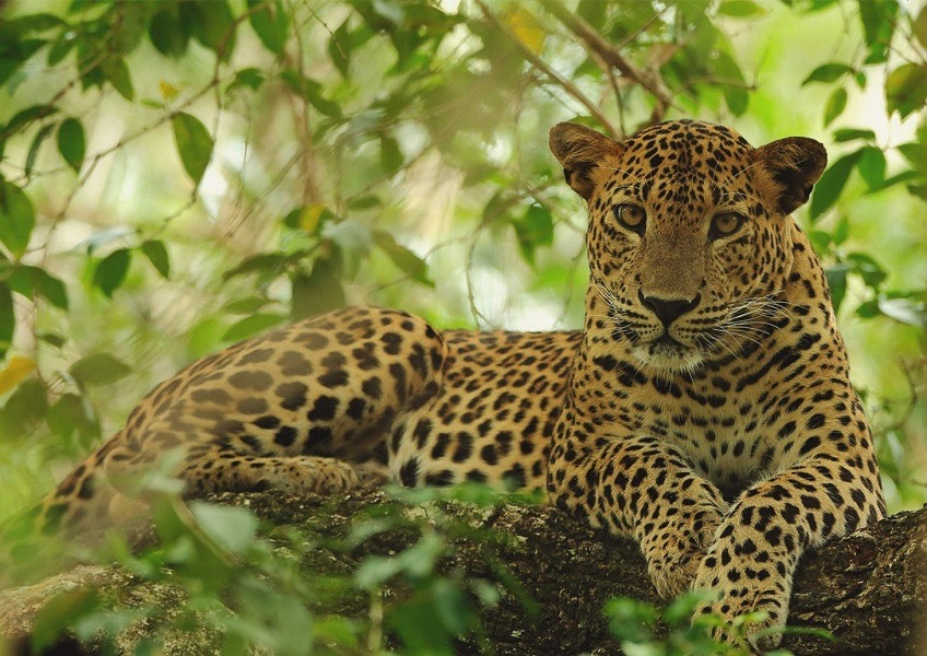
At a distance of 21 km from Tissamaharama, 111 km from Ella, 164 km from Nuwara Eliya, 172 km from Galle, 225 km from Bentota, 247 km from Kandy, 283 km from Sigiriya, 304 km from Colombo, 336 km from Anuradhapura, and 373 km from Trincomalee, Yala is a national park located in the southeastern region of Sri Lanka. It is the most popular national park in Sri Lanka and among the must include places in Sri Lanka Tour Packages.
Extends over the Hambantota district of southern province and Monaragala district in Uva province, Yala is the second largest national park as well as the most visited national park in Sri Lanka due to its high density of leopards. Ironically, the park was initially used as a hunting ground for the elite under British rule. Situated in Sri Lanka's south-east hugging the panoramic Indian Ocean, Yala was designated a wildlife sanctuary in 1900 and was designated a national park in 1938. Yala combines a strict nature reserve with a national park.
Divided into 5 blocks, the park has a protected area of nearly 130,000 hectares of land consisting of light forests, scrubs, grasslands, tanks, and lagoons. Though Yala spreads over a vast area, only two of its designated blocks are open to the visitors while the remaining area is a strictly designated Natural Reserve. The rocky outcrops scattered over the park provide vantage points to enjoy the sprawling areas with Sri Lanka's dry zone landscape. ...
At a distance of 100 km from Sigiriya, 106 km from Anuradhapura, 108 km from Dambulla, 133 km from Polonnaruwa, 182 km from Kandy, 236 km from Jaffna and 269 km from Colombo, Trincomalee is a charming coastal town on the northeast coast of Sri Lanka. It is the administrative headquarters of the Trincomalee district and among the must include destinations in Sri Lanka trip.
Sitting prettily on a remarkable natural harbour, the charming town of Trincomalee with oodles of history and interesting sites is a great escape from the touristy south. The port town is built on a peninsula of the same name, which divides its inner and outer harbours. The town got its historic Tamil name Thirukonamalai from Koneswaram Temple situated on the Swami Rock. Trincomalee is an anglicized form of the old Tamil word 'Thiru-kona-malai', meaning 'Lord of the Sacred Hill'. Trincomalee has been one of the main centers of Sri Lankan Tamil language speaking culture on the island for over two millennia.
Trincomalee known as Gokanna, Gokarna or Siri Gonamala, has a recorded history of more than 2500 years, beginning with the civilian settlement associated with the Koneswaram temple in the pre-modern era. One of the oldest cities in Asia, it has served as a major maritime seaport in the international trading history of the island with South East Asia. In the ancient world, it was successively the capital of eastern kingdoms of the Vanni ...
At a distance of 7 km from Dambatenne, 15 km from Haputale and 27 km from Ella, Lipton's Seat or Lipton Seat is a viewpoint situated in the Haputale mountain range, atop the Dambatenne Tea Estate. It is one of the popular vantage points near Ella.
Located at a height of 1970 m above sea level, Lipton's Seat is a beautiful tourist attraction that offers awe-inspiring views of the surrounding verdant hills and tea plantations. The viewpoint is named after Sir Thomas Lipton, the founder of Lipton Tea. This precise spot is the place where Sir Thomas Lipton used to sit and contemplate his plantations. A statue of Sir Lipton greets visitors to Lipton's Seat.
From the summit, one will have a bird's eye view of the Uva, Sabaragamuwa, Central and Eastern provinces. On a clear day, one should be able to spot the Handapanagala Lake, the Chandrika Lake and the Udawalawe Lake as well as the Wedihiti Kanda mountain range. This place is also perfect to witness the best of sunrise and sunset. The little kiosk at the plateau also sells Lipton's Ceylonta Tea. One can also visit the nearby Dambatenne Tea Factory to understand the process of tea production. The factory conducts an informative 20-minute guided tour to its visitors.
From Dambatenne town, there is a small road that winds its way up through the tea plantations to the viewpoint and every bus must take this road regardless of where you start from and only drops you at the entrance gate which is 1.5 km from the viewpoint. ...
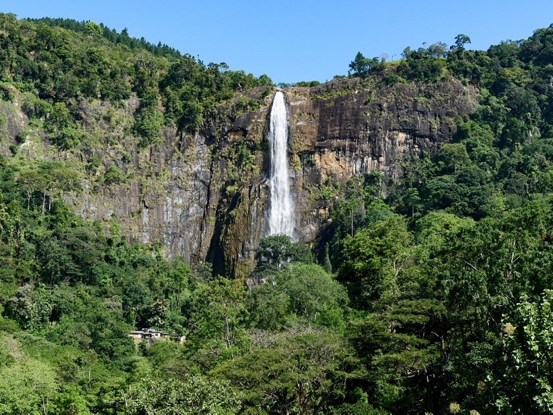
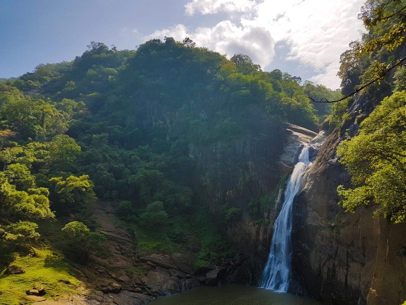
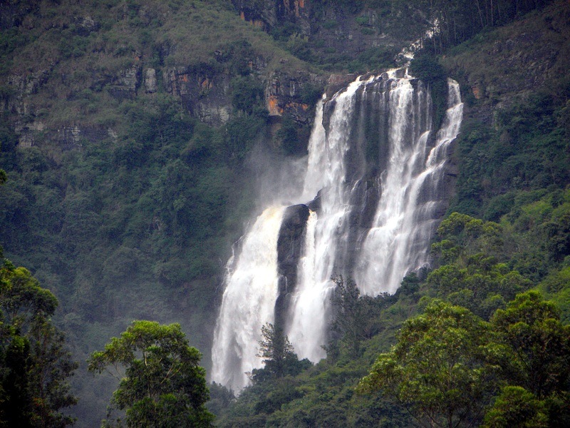
At a distance of 30 km from Haputale and 40 km from Ella, the Diyaluma Falls is a stunning waterfall located at Koslanda in Sri Lanka. On Colombo-Badulla highway, it is one of the best waterfalls in Sri Lanka and among the famous Ella Tourist Places.
Diyaluma Falls is cascading down from a height of about 220 m (720 feet) with several beautiful natural infinity pools at different levels along its length. It is the second-highest waterfall in Sri Lanka and 361st highest waterfall in the world. The waterfall is formed by Punagala Oya, a tributary of Kuda Oya which in turn, is a tributary of Kirindi Oya. In Sinhalese, Diyaluma or Diya Haluma means 'rapid flow of water' or may be translated as 'liquid light'.
It has two different sets of waterfalls- the Upper Diyaluma Falls and the Lower Diyaluma Falls. The upper waterfall is beautiful and has pools deep enough to jump into, but the dramatic drop-off is at the lower part of the falls. The pools were cool and refreshing, especially after the short hike in the heat. The adrenaline lovers are sure to be thrilled at the prospect of dip close to the brink of the cliffs, or a jump from one pool at the upper level to another pool below.
There are several ways to reach the falls. One route starts at Makaldenya Junction on Poonagala Road, which is far shorter and easier. It will take 30 minutes to reach Diyaluma Upper falls. The hike was almost entirely downhill and passes through the long grass but the trail was marked ...
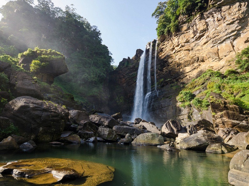
At a distance of 6 km from Badulla and 23 km from Ella, Dunhinda is a beautiful waterfall near Badulla in the lower central hills of Sri Lanka. It is one of the most beautiful waterfalls in Sri Lanka and among the must-visit places in Ella.
Dunhinda Falls flows down from an altitude of 63 m into a pool at the bottom. The fall is formed by a stream named Badulu Oya. The falls got its name from the smokey surrounding spray. The word Dun in Sinhala translates to smoke, and Hinda means 'evaporate'. It is also known as bridal fall, as the shape of the waterfall is similar to a bridal veil.
Dunhinda Falls is believed to have been occupied by the Vedda tribe, native to the country. During the reign of King Rajasinhe, a huge fern became lodged at the top of the waterfall which led to the flooding of Badulla. On witnessing this, the king ordered an individual named Ranhavadidaraya to clear the gate. After toiling for three months he managed to clear the water and the town re-emerged. The fern was swept away but got stuck again at a place now known as Pussellawa ('pus' meaning fern).
The trek to Dunhinda Falls is around 1.5 km long from the entrance and is moderately challenging. The clear path consists of small bridges and steep steps. There are safety wooden and iron handrails. But the view of the falls at the end of the trail is worth the long trek. Along the way, the Small Dunhinda falls, and diverse fauna such as butterflies, monkeys, and birds can be spotted. ...
At a distance of 30 km from Colombo, Panadura Beach is a public beach at Panadura town situated in the Western Province of Sri Lanka. Along the coast of the Indian Ocean, Panadura is one of the mesmerizing beaches near Colombo and among the best places to visit as part of Sri Lanka Tour Packages.
Panadura Beach is a quiet secluded beach with a long stretch of golden sands and clear waters which are perfect for candid moments with the beach. Just like the town of Panadura, its beach too speaks of elegance, warmth, and simplicity at its best. It is not widely regarded for its water adventures of scuba diving and snorkeling along with the usual hustle of nightlife on the coasts. However, Panadura presents a landscape for some edgy family time and romance by the seas with your loved ones.
Kite flying is a favorite activity on the beach, and one can buy a kite from the shops outside the beach. The breeze and a slight technique with your hands will do the trick for a beautiful kite flying experience. Yoga in the mornings is highly sought after by the tourists. With the sound of the waves crashing against the sandy shores, there is no stopping the inner goodness. The sea is too rough for swimming. Make sure to take a dip in the designated places marked safe by guards.
The beach is crowded on weekends or on a Poya Day as it is a national holiday given on the account of the full moon every month in Sri Lanka.
Timings: 6 AM - 7 PM
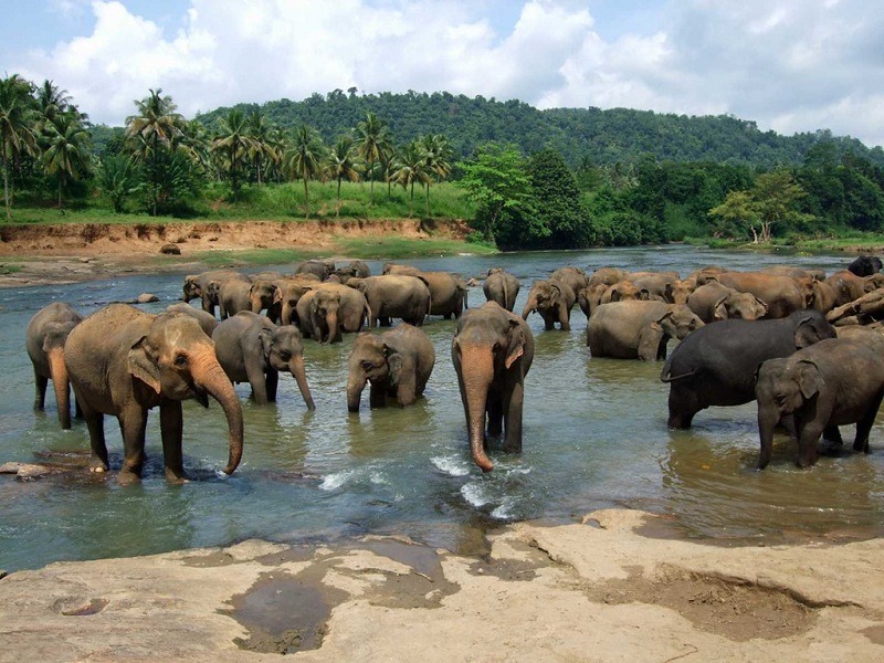
At a distance of 41 km from Kandy and 92 km from Colombo, Pinnawala Elephant Orphanage is an orphanage, nursery and captive breeding ground for wild Asian elephants located at Pinnawala village in Sabaragamuwa Province of Sri Lanka. It is one of the popular attractions to visit in Kandy as part of Sri Lanka Packages.
Pinnawala Orphanage was established in 1975 CE by the Sri Lanka Department of Wildlife Conservation in a 25-acre coconut property adjoining the Maha Oya River. It was originally founded for feeding and providing care to many orphaned baby elephants found in the jungles of Sri Lanka. The operations of this site began by rescuing and nurturing 5 abandoned baby elephants from the dense forests of Sri Lanka. The orphanage was taken over by the National Zoological Gardens from the Department of Wildlife in 1978 and a captive breeding program was launched in 1982. Since the inception of the program over 20 elephants have been bred here.
The addition of orphans continued till 1995 when the Elephant Transit Home (ETH) adjoining Udawalawe National Park was created by the Department of Wildlife Conservation. Since then, orphaned babies have been taken to the ETH and addition to the Pinnawala herd has been mostly through births occurring there. As of 2012, there were 78 elephants and about 48 mahouts who take care of the elephants. The female and young elephants in Pinnawala range freely as a herd during the day in an area of a few acres. At night, the females ...
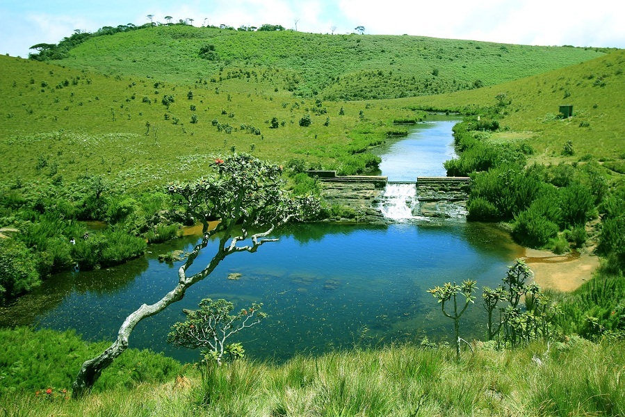
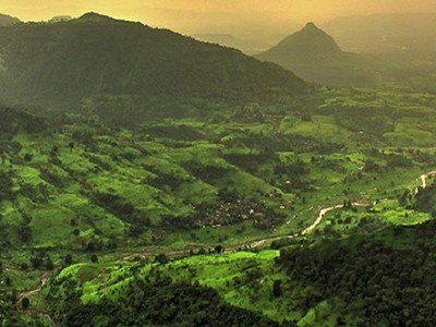
At a distance of 10 km from Ohiya, 29 km from Nuwara Eliya and 48 km from Ella, Horton Plains National Park is a protected area in the central highlands of Sri Lanka. It is one of the most beautiful World Heritage Sites in the world and among the prime places to visit in Nuwara Eliya during Sri Lanka Tour.
The great Horton Plains was discovered by the planter Thomas Farr in the early 19th century. The original name of the plains was Maha Eliya, meaning 'great open plains,' but it was renamed in 1834 after Robert Wilmot-Horton, the then Governor of Ceylon. Horton Plains was designated as a wildlife sanctuary in the year 1969 and was elevated to a national park in 1988. The Peak Wilderness Sanctuary which lies in the west is contiguous with the park. And, in 2010, the Central Highlands of Sri Lanka which incorporates Horton Plains National Park, Peak Wilderness Sanctuary and the Knuckles Mountain Range was inscribed on the World Heritage List.
The Horton Plains National Park is spread over the two highest mountains in the area called Kirigalpotta (2395m) and Totapola (2359m). The 'plains' form a plateau of rises and fall over 2000m high, covered by wild grasslands and interspersed with patches of thick forest, rocky outcrops, filigree waterfalls, and misty lakes. The plateau's sudden end is famously known as 'World's End', a stunning near 880m drop. These plains are the headwaters of three major Sri Lankan rivers, ...
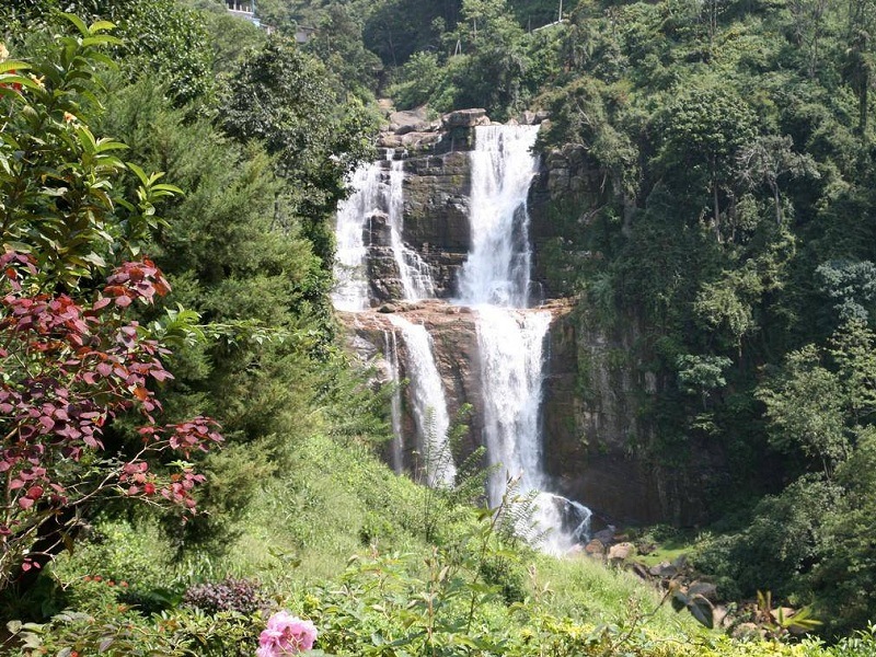
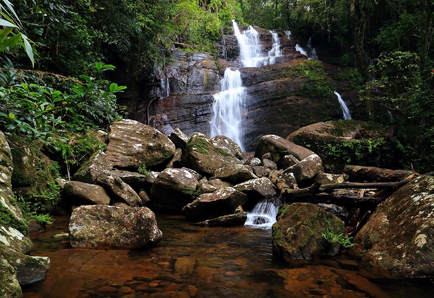
At a distance of 25 km from Nuwara Eliya, Ramboda Falls is a spectacular waterfall situated at Ramboda near Nuwara Eliya town of Sri Lanka. It is one of the beautiful waterfalls in Sri Lanka and among the must-visit places in Nuwara Eliya.
Also known as Ramboda Ella or Puna Ella, Ramboda Falls is originally two separate waterfalls that have two different sources and combines at the base to form a Y shape. One cascade is the Puna Falls or Ramboda Falls that has its source from the Puna Oya and the second cascade is called the Dunsinane Falls that has its source from the Pundalu Oya, the tributaries of Kothmale River. Cascades down from a height of about 358 feet, it is the 11th highest waterfall in Sri Lanka and 729th highest waterfall in the world.
It is situated in the Pussellawa area on the A5 highway at Ramboda Pass. There are three recognizable falls very close to each other. Middle falls lies right by the side of the A5 highway. The upper part and bottom parts are on the sides of the road. The Y shaped tiered waterfall is in the upper part. To reach the upper part, there is kind of a hike around 1-2 km. It serves to be a great landmark and resting spot for travelers as it provides surreal natural sceneries of the mountains draped in the evergreen landscape of tea plantations.
Timings: 9 AM - 5 PM
Entry: Free
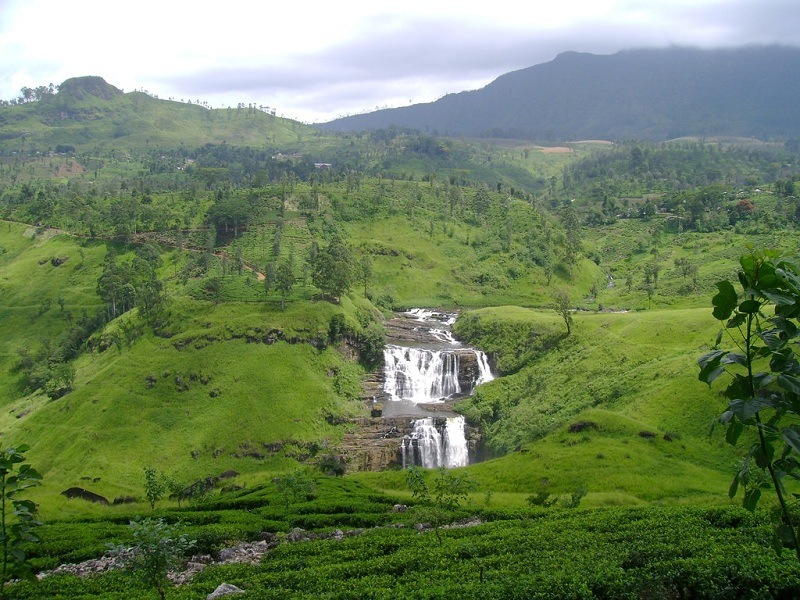
At a distance of 25 km from Nuwara Eliya, St. Clair's Falls is a beautiful waterfall situated at Talawakele town in Nuwara Eliya district of Sri Lanka. It is one of the popular waterfalls in Sri Lanka and among the prime places to visit in Nuwara Eliya.
The falls are formed over the Kotmale Oya, a tributary of the Mahaweli River. This majestic waterfall cascades over three rocky outcrops into a large pool. It runs through Saint Clair Tea Estate, from which the falls got the name. The waterfall consist of two falls called 'Maha Ella' means 'The Greater Fall', and 'Kuda Ella', means 'The Lesser Fall'. The Maha Ella is about 260 feet high and 160 feet wide while the Kuda Ella is about 160 feet high and is located immediately downstream of the main fall. St Clair's falls is the widest waterfalls in Sri Lanka and is commonly known as the 'Little Niagara of Sri Lanka'.
It is one of six waterfalls affected by the Upper Kotmale Hydropower Project. The falls are located 2.2 km downstream from the dam. However, the Government has stated that they will release a limited quantity of water to ensure a continuous flow of 47,250 cubic meters water over the falls for 10 hours and 30 minutes daily.
The fall is located about 500 m away from the road, and one needs to walk to reach it. The trek is exciting as the walking trail goes through tea gardens at a steep gradient. The beauty of the green tea estate is an added advantage!
Timings: 6 AM - 5 PM
Entry: Fre ...
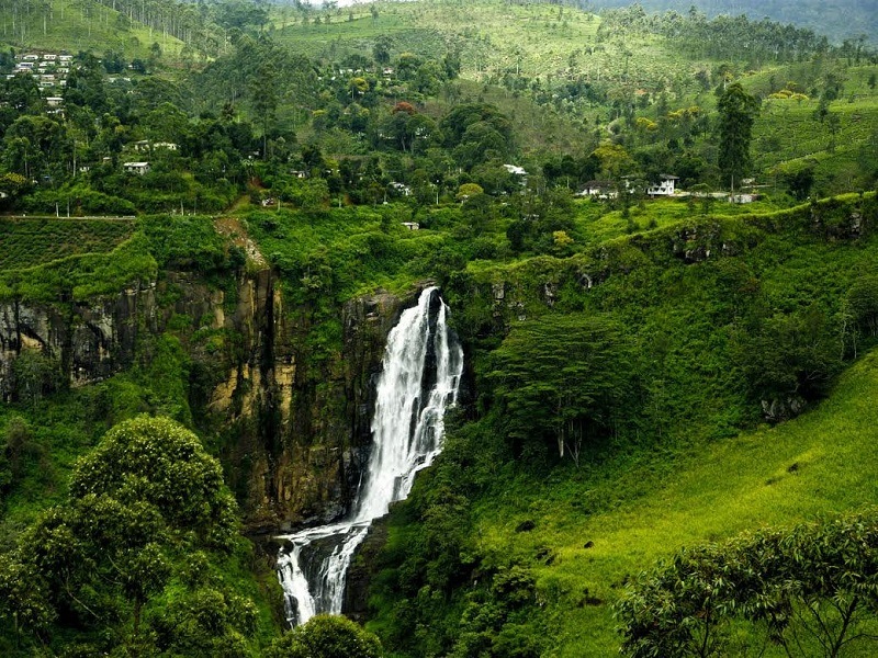
At a distance of 7 km from Talawakale and 30 km from Nuwara Eliya, Devon Falls is a stunning waterfall situated at Dimbula village in Nuwara Eliya district of Sri Lanka. Situated very close to St. Clair's Falls, it is one of the popular waterfalls in Sri Lanka and among the major places to visit in Nuwara Eliya.
Also known as the 'Veil of the Valley', Devon Falls is cascading down from a height of about 97 m (318 feet) and is considered to be the 19th highest waterfall in the island country of Sri Lanka. The falls are formed by Kothmale Oya, a tributary of Mahaweli River. It has three drops, each progressively broader and is named after a pioneer English coffee planter called Devon, whose plantation was situated nearby the falls.
One would have to walk roughly up to a kilometer through the lush green tea plantations from the 20th-mile post in order to get closer to the waterfall. However, one can also get a clear view of the falls from the main road. There are two viewpoints on the A7 from which this remarkable waterfall could be observed. One would be the viewpoint1 near Devon Holiday Bungalow, which is preferred by most tour guides and tourists since this observation point gives its visitors a glimpse of both Devon Falls and St. Clair's Falls too. The second point of observation would be near Mlesna Tea Castle.
Timings: 6 AM - 6 PM
Entry: Free
At a distance of 17 km from Maskeliya, 31 km from Hattan and 70 km from Nuwara Eliya, Laxapana Falls is a mesmerizing waterfall situated at Kiriwan Eliya village in Nuwara Eliya district of Sri Lanka. Located on Maskeliya-Norton Bridge road, it is one of the popular waterfalls in Sri Lanka and among the major places to visit in Nuwara Eliya.
The picturesque waterfall that cascades down from an enormous height of 413 feet, is formed by Maskeliya Oya, a major tributary of the Kelani river. This is the 8th highest waterfall in Sri Lanka and 625th highest waterfall in the world. According to legend, this is the place where Buddha mended his saffron robe when he was visiting Adam's Peak. The name of the falls derived from Sinhala words of 'Laxa' means Hundred thousand and 'Pana' translates to lamps.
The waterfall is a cascade of silvery foam amid lush greenery that flows to form a fabulous natural pool at the bottom. The fall gives its name to twin hydroelectric power stations, Old Laxapana Power Station which generates 50 MW of electricity and New Laxapana Power Station which generates 100 MW. It is quite a difficult waterfall to hike and caution should be taken while taking a dip due to the flow of the water.
A stunning view of the fall can be enjoyed from the road between Norton bride and Maskeliya. If you want to go closer take the road from Polpitiya power station. Otherwise, take the road from Maskeliya to Norton Bridge and within 13 km there is a subsidiary ...
At a distance of 13 km from Hagkala Botanical Gardens and 19 km from Nuwara Eliya Bus Stand, Bomburu Ella is a waterfall at Uva-Paranagama Divisional Secretariat of Sri Lanka. Located near the border of Nuwara Eliya and Badulla districts, Bomburu Ella is the widest waterfall in Sri Lanka and among the must-visit places in Nuwara Eliya.
Also known as Perawella Falls, it is falling from a height of about 165 feet (50 m). The waterfall is a collection of about 10 little-known jungle waterfalls, situated between 1500 and 2000m above sea level in the Sita Eliya Kandapola Forest Reserve. They are served by the upper segment of the principal tributary of the Uma River, known as the Duulgala River. The waters of the Bomburu Ella Fall has been diverted to a powerhouse located in the area and is utilized for cultivation purposes.
The starting point of the trek to the top of Bomburu Ella Fall will be at the Bomburu Ella village, which can reach by public transport, tuk-tuk or private vehicle. The road is in good condition up to the village where you start the 2 km hike to reach the waterfall. Parking spaces will be available at the starting point of the hike, for convenience and ease of access. There are two entry options - the first one is near the bus stop with stairs up to the top while the second one is the narrow road towards the village which is much easier. However, both roads meet at a point near the top which is a snack spot with few small stalls set up by the villagers.
Please ...
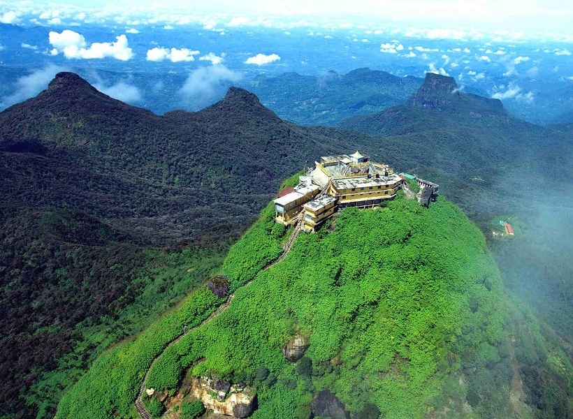
At a distance of 71 km from Nuwara Eliya, Adam's Peak is a conical mountain located in the Sri Pada Wilderness Sanctuary, which is one of the largest sanctuaries in Sri Lanka. It is one of Sri Lanka's most striking natural landmarks and among the most celebrated places of pilgrimage in Sri Lanka.
Also known as Sri Pada and Samanala Kanda, Adam's Peak is standing at 2,243 m (7,359 feet) tall in the central highlands of Sri Lanka. Trekking up the mountain is extremely popular with both tourists and locals, who are allured by its mystery as well as the enchanting beauty they are rewarded with at the top. The mountain is also known for the spectacular sight of thousands of beautiful butterflies gracing the area annually.
The mountain has accumulated a number of legends centered around the curious depression at its summit, the Sri Pada or Sacred Footprint. The original Buddhist story claims that this is the footprint of the Buddha himself, made at the request of the local god Saman. Hindus believed that the footprint belongs to Shiva while Muslims claimed that the footprint to be that of Adam. Many centuries later, the colonial Portuguese attempted to rescue the footprint for the Christian faith, claiming that it belonged to St. Thomas. Despite all these rival claims, Adam's Peak remains an essentially Buddhist place of worship since the Polonnaruwa period.
The ascent of Adam's Peak is traditionally made by night, allowing visitors to reach the top in time for ...
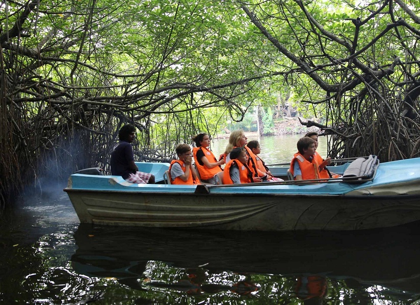
At a distance of 19 km from Bentota Railway Station, Madu Ganga River Safari is one of the top things to do in Bentota while holidaying in the island country as part of Sri Lanka Tour Packages.
Situated at Balapitiya, Madu Ganga is the second biggest wetland in Sri Lanka. Abundantly rich in biodiversity, the river covers at least 150 acres of land and consists of 14 mangroves out of the 24 mangrove species found in Sri Lanka. The Madu Ganga wetland is considered to be one of the last remaining tracts of mangrove forests. It is the best place to watch prawn farming and traditional fishing methods. It is also home to 300 species of plants and about 250 wildlife species which makes it a haven for the ecologists and the botanists.
Visitors can book themselves for boat rides and bird-watching rides. Accompanied along with trained professionals and local fishermen, the Madu River safari begins at the mouth of Madu River at Balapitiya, which lasts between 1 to 2 hours and visitors have the opportunity to see a large area of the wetland. The boat traverses through thick mangrove forests, which provide protection to a large number of aquatic birds, animal and plant species. One can get a chance to see crocodiles, water snakes, tree snakes, and wild boars in their natural habitat during the boat ride.
The river also consists of 25 islands, out of which only 15 are of sizeable landmass and safe to visit. One island where the motorboat halts at is the Cinnamon Island ...

At a distance of 18 km from Galle and 37 km from Bentota, Hikkaduwa Beach is a serene beach situated in the coastal town of Hikkaduwa. It is one of the popular beaches on the island as part of the Sri Lanka Tour.
The beach of Hikkaduwa was the first (the 1960s) beach discovered by tourists in Sri Lanka. The beach stretches over 4 kilometers and hosts many fun activities to keep the tourists engaged. These water sports include snorkeling, scuba diving, whale watching, swimming in the ocean and glass boats for the adventure seekers. The clear waters beckon the nature lovers who wish to take a dip inside the waters to witness the vibrant, colorful aquatic life. The coral sanctuary found along the coast of Hikkaduwa hosts gorgeous coral formations. Off the beach, there is a collection of small islets surrounded by beautiful coral formations. Many species of fish and large turtles are found here.
Hikkaduwa offers some of the best scuba diving experiences in Sri Lanka as it has unique dive sites such as wreck dives and spectacular reef dives. There are more than four different shipwrecks for diving enthusiasts to explore along with dive shops offering PADI courses and equipment. Also, Hikkaduwa is an international destination for board-surfing and even featured in Anthony Bourdain's television show 'No Reservations'.
The beach has resto-bars, pubs and a vibrant nightlife. One can also visit Narigama Beach, Sea turtle hatching and rescue center, Tsunami Photo Museum, ...
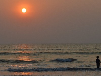
At a distance of 30 km from Unawatuna and 35 km from Galle, Mirissa Beach is a beautiful sandy shore located along the mighty Indian Ocean in the coastal town of Mirissa, Sri Lanka. It is one of the popular beaches on the Southern coast of the island and among the best places to visit near Galle.
Mirissa Beach is relatively large with plenty of space to lay down and just relax and watch the beach life. The beach has clean sand and clear waters that are lined with palm trees. At one end of the Mirissa Beach is a rock formation, known as Parrot Rock that is surrounded by the ocean on three sides. Tourists can climb on top of the rock and witness a gorgeous panoramic view of the Mirissa Beach.
The stunning Mirissa Beach is a popular site for water sports, such as surfing and snorkeling, which are always on demand. Besides, Mirissa is hugely famous for its whale watching and dolphin watching activities. Whale watching in Mirissa allows visitors to enjoy watching them swim and play in their natural habitat. There are many tour companies that offer whale and dolphin watching tours. The price for whale watching in Mirissa ranges from LKR 5000 to LKR 10000, depending on the tour operator and the package they offer. The boat rides last for an average of three to five hours.
Along the beach are plenty of small restaurants and cafes, serving delicious and fresh seafood. After dark, the restaurants put out tables on the beach, light lanterns, and candles, and serve seafood ...
At a distance of 80 km from Galle, Sinharaja Forest Reserve is a forest reserve and a biodiversity hotspot in Sri Lanka. It is one of the very few virgin rainforests in the world and among the prime places to visit in Sri Lanka for nature lovers.
Sinharaja is the last viable area of primary tropical rainforest in Sri Lanka. More than 60% of the trees are endemic and many of them are considered rare. The hilly virgin rainforest, part of the Sri Lanka lowland rain forests ecoregion, was saved from the worst of commercial logging by its inaccessibility. This reserve was once a royal reserve and in some colonial records, it is referred to as Rajasinghe Forest. It was designated a World Biosphere Reserve in 1978 and a World Heritage Site in 1988. The reserve's name translates as the Lion Kingdom.
The reserve is only 21 km from east to west, and a maximum of 7 km from north to south, but it is home to over 50% of Sri Lanka's endemic species of mammals and butterflies as well as many kinds of insects, rare amphibians and reptiles. Due to its dense vegetation, not many animals and birds are seen as it is in other forest reserves and national parks. There are about 3 elephants and 15 leopards. The most common larger mammal is the endemic purple-faced langur. Also, the Sinharaja Forest Reserve is home to more than 30 species of birds that are endemic to Sri Lanka along with many species of migratory birds. There are 22 villages around the forest, and the local people are permitted ...
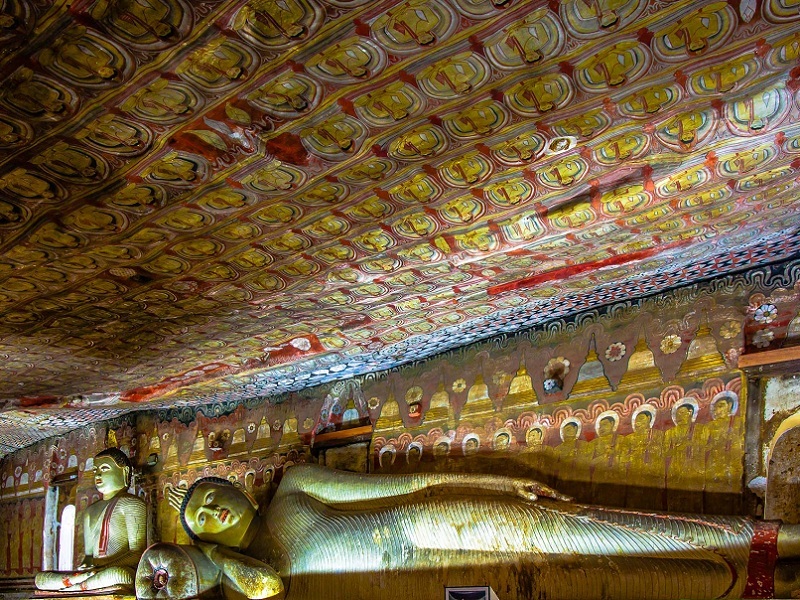
At a distance of 3 km from Dambulla Bus Station, 17 km from Sigiriya and 73 km from Kandy, Dambulla Cave Temples is an ancient cave temple complex situated at Dambulla in Sri Lanka. It is one of the popular places of pilgrimage in Sri Lanka and among the must-visit places for heritage lovers as part of Sri Lanka Packages.
Sitting on top of a 160-meter high rock, the Dambulla Cave Temple, also called as Golden Temple of Dambulla, has been a sacred pilgrimage site for 22 centuries and is one of the five UNESCO World Heritage Sites that the tiny island possesses. It is the best-preserved and most extensive cave temple complex of the country comprising of five main caves, each possessing numerous statues of Lord Buddha, some figures of kings and statues of Lord Vishnu along with Rock Paintings of vivid colours and shapes from around 2nd Century BC (Anuradhapura era) and continued up to the Kandyan era of the 18th Century. Dambulla is also a part of the 'Cultural Triangle' of Sri Lanka along with the town of Sigiriya and the city of Kandy.
The caves of Dambulla were occupied in very early times by Buddhist hermits. The Dambulla Rock Temple had first been constructed during the reign of King Vattagamini Abaya. During a South Indian invasion, the king sought refuge here for 15 years. After regaining the kingdom of Anuradhapura, to show his gratefulness for his safe place, he converted those caves into Buddhist Temples by constructing walled partitions under the rock overhang ...
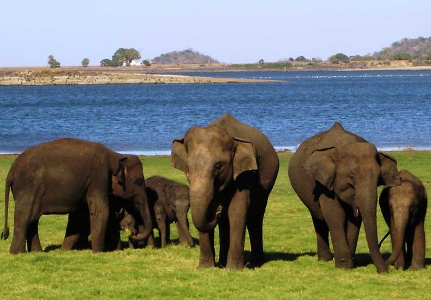
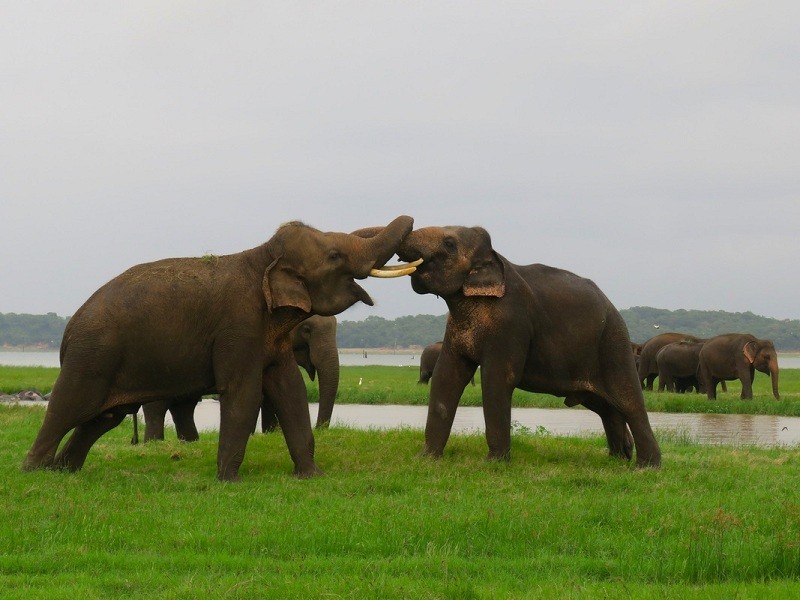
At a distance of 23 km from Sigiriya, 40 km from Polonnaruwa and 68 km from Anuradhapura, Minneriya National Park is a national park situated in the North Central Province of Sri Lanka. It is one of the best places to see wildlife in Sri Lanka.
The area was declared as a wildlife sanctuary in 1938 and was designated as a national park in the year 1997. The main reason for declaring the area as a protected reserve is to conserve the flora and fauna that surrounded the Minneriya Tank. The tank is of historical importance, having been built by King Mahasen in 3rd century AD and derives water from the Amban River, and the Elahera Canal. The park is a dry season feeding ground for the elephant population dwelling in the forests of Matale, Polonnaruwa, and Trincomalee districts.
Covering an area of 89 sq. km, the park has plenty of scrubs, forests, and wetlands. Minneriya is home to 24 species of mammals, 160 species of birds, 9 species of amphibians, 25 species of reptiles, 26 species of fish, and 75 species of butterflies. Minneriya is one of the best places in the country to see wild elephants, which are often present in huge numbers. Besides elephants, one can also spot leopards, sloth bear, spotted deer, wild buffalo, wild pig, purple-faced langur and toque macaque here.
The best way to enjoy the park is through jeep safari. The park offers two safaris in a day one in the morning (6 AM) and the other in the late afternoon (3 PM). Each safari tour lasts 3 hours. ...
At a distance of 20 km from Habarana, 38 km from Sigiriya, 36 km from Polonnaruwa, 75 km from Trincomalee and 82 km from Anuradhapura, Kaudulla National Park is a national park situated near the town of Galoya in Polonnaruwa district of North Central Province in Sri Lanka. It is one of the best national parks on the island which can be visited as part of Sri Lanka Packages.
Kaudulla National Park is one of Sri Lanka's youngest national parks, having only been designated a protected area in 2002, becoming the 15th nature reserve on the island. Along with Minneriya and Girithale, BirdLife International has identified Kaudulla as an Important Bird Area. The Kaudulla reservoir which lies in the center of the reserve is the main focal point of wildlife in the park. Historically Kaudulla was one of the 16 irrigation tanks built by King Mahasen. Following a period of abandonment, it was reconstructed in 1959. The two-third area of the park is underwater during several months of the year as it is home to the Relapanawa reservoir, Olumadu Wewa reservoir, Puliyan Kalla wewa reservoir, Minneriya-Kanthale Yoda Ela canal, Aluth Oya stream and Hatharas Kotuwa Oya along with the historical Kaudulla reservoir.
Covering over an area of 6656 ha, this dry evergreen forest is home to 24 species of mammals, 25 species of reptiles, 26 species of fish, and 160 species of birds. The elephants at Kaudulla are the main stars of the National Park. August to September is the best period to ...
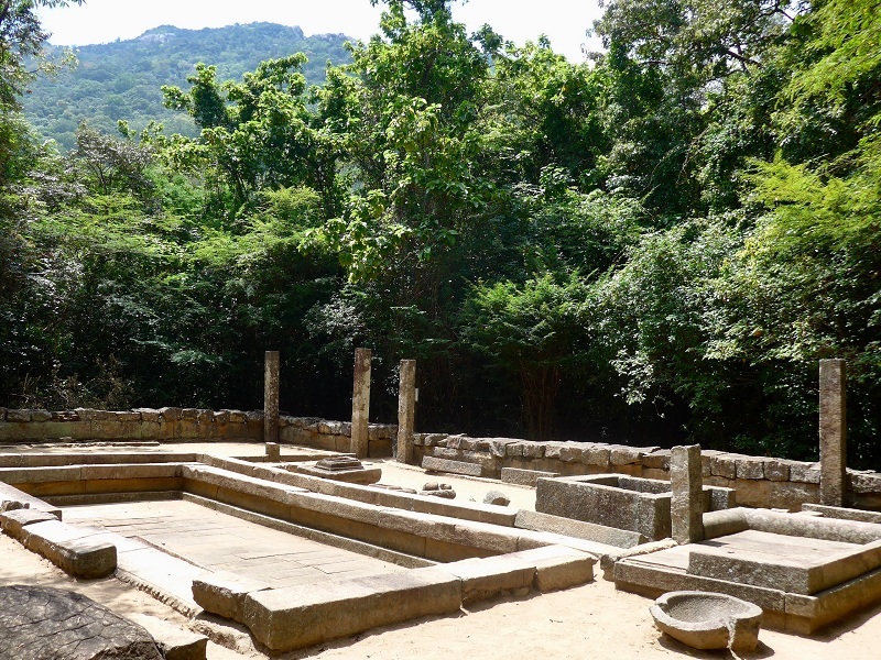
At a distance of 14 km from Anuradhapura, Mihintale is a Buddhist pilgrimage site and religious complex situated near Anuradhapura. It is one of the popular pilgrimage places in Anuradhapura and among the must-visit places as part of Sri Lanka's Cultural Triangle Tour.
Mihintale is revered as the birthplace of Buddhism in Sri Lanka. According to legend, it was at Mihintale that the Indian Buddhist monk Mahinda Thera met and converted King Devanampiya Tissa to Buddhism in 247 BC. Mahinda was the son of the great Mauryan emperor Asoka, sent by his father to bring the word of the Buddha's teachings to Sri Lanka. Mihintale, literally Mahinda's Mountain, eventually became the cradle of Buddhism and Sinhalese culture.
With the arrival of Buddhism in Sri Lanka, Mihintale Mountain began to serve as a residential area for the venerable monks headed by Arahath Mahinda Mahathera. But soon, with the royal patronage, the sanctuary housed a multitude of monastic buildings, stupas, uposathgharas, and bodhigharas to serve the monks. Sixty-eight cave dwellings provided the monks' shade and shelter. With the growth of the community of monks and the pious laymen, King Sena II (853-887 AC) had built a hospital at the base of the mountain. Thankfully the ruins of some of these buildings can still be seen today, making Mihintale the perfect day trip from Anuradhapura.
The great stairway is another feature of Mihintale that is situated on the eastern side of the slope in 4 sections. ...
At a distance of 21 km from Habarana, 32 km from Sigiriya and 56 km from Anuradhapura, Ritigala is an ancient Buddhist monastery and mountain situated in Ritigala Strict Nature Reserve of Sri Lanka. It is one of the popular heritage places to visit in Anuradha as part of the Sri Lanka Tour.
At a height of 766 m above sea level, Ritigala is the highest mountain in the north-central dry plains of Sri Lanka. The mountain mass about three miles long and about two miles wide at its widest point is covered with dense jungle inhabited by wild elephants, leopards, and bears. It is the watershed of the Malwatu Oya which feeds the Nachaduwa tank and Kalueba Ela which feeds Huruluwewa. The Ritigala Mountain has been declared a Strict Natural Reserve in order to maintain its pristine environment.
Ritigala is home to 70 rock caves that were believed to had been inhabited since the first century BC. Mahavamsa, the great historical chronicle of Sri Lanka narrates that Ritigala was known by the name of 'aritta-pabbata' during the reign of Pandukabhaya (377-307 BC). With the exception of a few broken granite Buddha statues in a number of caves, Ritigala has none of the traditional icons of Buddhist temples- no bo tree, no stupas. The first Lanka Vihare was founded near Ritigala at the foot of the mountain in the second century BC. The Aritta Vihare was founded a century afterward. In the ninth century AD, King Sena made an endowment of the monastery, a larger complex higher up the ...
At a distance of 40 km from Anuradhapura and 52 km from Puttalam, Wilpattu National Park is a park situated at Hunuwilagama in Sri Lanka. Located on the western coast of the Island, it is the oldest and the largest national park in the country.
The park has earned its name from the numerous 'villus' (natural lakes in Sinhalese) that spread across the area. Wilpattu was declared a wildlife sanctuary in the year 1905 and designated as a national park in 1938. The park was closed down for more than two decades during the Sri Lankan Civil War and was reopened to the public in 2010. Ancient ruins such as stone pillars have been discovered in the national park, near a 'villu' called Kali. It is widely believed that these are the remains of the palace of Queen Kuweni, wife of Sri Lanka's first ruler, King Vijaya.
Covering over an area of about 1,317 sq. km, the park has nearly 50 lakes and tanks within its precincts. Wilpattu is among the top national parks world-renowned for its leopard population. Apart from the leopards, one can spot a multitude of other mammals and reptiles at Wilpattu, such as the Sri Lankan elephant, sloth bear, spotted deer, Indian python and monitor lizards. The bird species at the national park includes Sri Lankan jungle fowl, whistling teal and painted storks. Interestingly, the national park also has a specific historical significance.
Jeep Safari is the regular norm in exploring the Wilpattu National Park. While Leopards, Elephants, Sloth ...
At a distance of 1 km from Nilaveli Beach and 24 km from Trincomalee Railway Station, Pigeon Island is a marine national park situated off the coast of Nilaveli. It is a popular getaway from the city of Trincomalee and among the popular places for scuba diving & snorkeling in Sri Lanka.
Undoubtedly one of the best places to visit near Trincomalee, the Pigeon Island National Park was declared a marine sanctuary way back in 1963 and designated as a national park in 2003. This national park is the 17th in the country and one of the two marine national parks in Sri Lanka, the other being Hikkaduwa. The pristine and beautiful Pigeon Island National Park comprising of two small islands - Large Pigeon Island and Small Pigeon Island. Pigeon Island is one of the several protected areas affected by the Indian Ocean tsunami in 2004.
The national park is home to the vibrant marine life, stunning rock formations, and endangered rock pigeons, based on which the national park gets its name. Pigeon Island is also known to have the best coral reefs in the entire country. With a 200 m long and 100 m wide coral reef with nearly a hundred species of gorgeous corals, the Large Pigeon Island has an unmatched live coral reef with a high ecosystem and significant reef habitat. Surrounded by rocky islets, the Small Pigeon Island is a promising ground for feeding and breeding over 300 varieties of coral reef fish.
Pigeon Island is a heaven for people who are looking for a good ...
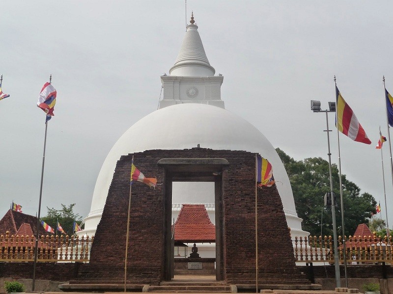
At a distance of 44 km from Trincomalee, Seruwila Mangala Raja Maha Vihara is an ancient Buddhist temple situated at Seruwawila in the Trincomalee district of Sri Lanka. It is counted amongst the holiest Buddhist sites in Sri Lanka and one of the top places to visit near Trincomalee.
Seruwila Mangala Raja Maha Vihara was built during the reign of King Kavantissa (2nd century BC). It is believed that three viharas existed at this particular spot that was built during the periods of three former Buddhas named Kakusandha, Koṇagamana, and Kassapa with their relics enshrined. Gautama Buddha had personally visited this place and offered eight handfuls of 'sapu' flowers, then wished that the temple which constructing in the future should be named as Mangala viharaya. The stupa containing the Lalata Dathun Wahanse (sacred forehead bone) of Lord Buddha and is among the sixteen holiest Buddhist shrines (Solosmasthana) in Sri Lanka.
Over the years, the stupa fell into ruins under the pressure of the Tamil invasions from the north. But there is evidence in the literature that this area was under the purview of the Kandyan territory during the 17th century and the existence of this stupa. It was only in 1922 that the dagoba was re-discovered by Dambagasare Sumedhankara Thero and he restored the stupa with the approval and supervision of the Department of Archaeology using remains of ancient structures around the stupa to conjecture the conservation work. The conservation ...
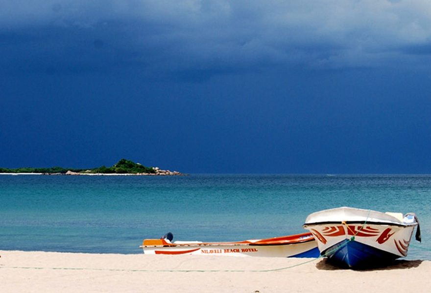
At a distance of 20 km from Trincomalee, Nilaveli Beach is a pristine palm-fringed beach situated at Nilaveli. Along the coast of the Indian Ocean, it is one of the popular beaches in Sri Lanka and among the prime Trincomalee Tourist Places.
Stretches over 1 km, Nilaveli Beach is a calm, serene white sandy beach surrounded by lush, green vegetation on both sides. The beach itself was really clean with no rubbish and the water is clean and calm ideal for swimming. Water sports such as windsurfing and diving are very famous among tourists and even locals. Totally unspoiled by the onslaught of tourism, this palm-fringed beach is perfect for a lazy, rejuvenating day by the sea.
Across the beach, about 1 km into the ocean one will see the famous Pigeon Island, named due to rock pigeons roosting on it. It is a famous spot for snorkeling and diving. The reef there provides a perfect place to explore the ocean.
Timings: 6 AM - 6 PM
Entry: Free
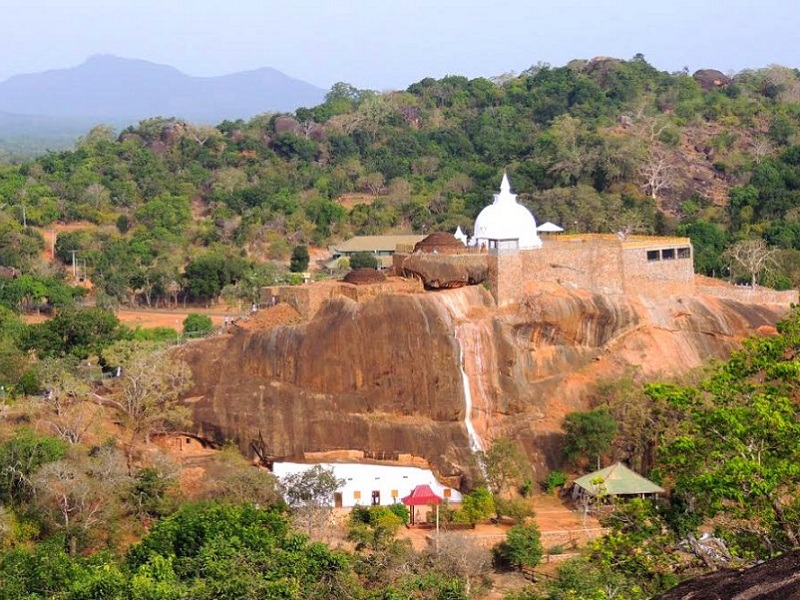
At a distance of 17 km from Kataragama, 22 km from Yala and 28 km from Tissamaharama, Sithulpawwa is an ancient Buddhist monastery located deep within the natural habitats of the Yala National Park, Sri Lanka. Located on Tissamaharama-Yodhakandiya road, it is one of the popular pilgrimage places to visit near Yala.
Sithulpawwa Rajamaha Viharaya is believed to have been built in the 2nd century BC by King Kavantissa. With a history of over 2200 years, this rock temple is considered to be one of the supreme 2nd-century sites of Buddhist scholarship. Sithulpawwa is known as a location where thousands of Arhaths lived at one time.
The monastery straddles a collection of rocky outcrops and caves deep in the heart of Yala National Park. There are said to be hundreds of caves and shelters within and around the complex that have housed monks (for centuries) who came to the site to further their education as well as to meditate. Surrounded by only the sounds of the wilderness and temple chants, a journey to Sithulpawwa is a peaceful escape that is fitting for its original name 'Chiththala Pabbatha', which means the hill of the quiet mind.
The temple is located atop a rock (400 feet high) hence one must climb a flight of stairs to get to the summit where the brilliance of the dagoba, rock caves and the view can be witnessed. Paintings of the Anuradhapura era and the ruins of stone Buddha images, Bodhisattva images, Image Houses, Circular Relic Houses are spread throughout ...
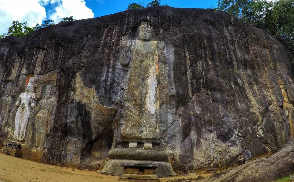
At a distance of 37 km from Ella, 68 km from Tissamaharama, 74 km from Kataragama and 88 km from Yala, Buduruwagala is an ancient Buddhist temple in Sri Lanka. Known for its magnificent rock carvings, it is one of Yala's best attractions.
The complex consists of seven statues and belongs to the Mahayana school of thought. The stunning rock-cut Buddha figures are nearly a 1000-year old. Buduruwagala means 'the rock of Buddhist Sculptures' and is derived from the words for Buddha (Budu), images (ruva) and stone (gala). Authorities generally date them to the 9th or 10th century but Buduruwagala does not have many historical records. It is thought to be a hermitage for monks. The sculptures of Buduruwagala also include many sculptures of Bodhisattva images including Mahayana tradition.
The enormous Buddha stands at 15m, becoming the highest on the island. One can still trace its unusual adhesive robe, along with an elongated splash of orange color, indicating it was once painted with vibrant colors. The adjoining is filled by smaller carved statures. The center of the three figures to the Buddha's right is thought to be the Buddhist mythological figure-the Bodhisattva Avalokitesvara. To the left of this white painted figure is a female figure in the thrice-bent posture, which is thought to be his consort-Tara.
Timings: 8 AM - 5 PM
Entry: Free

At a distance of 20 km from Tissamaharama and 38 km from Yala, Kataragama is a sacred town in Sri Lanka. It is one of the most significant pilgrimages in Sri Lanka and is regarded as one of the best places to visit in Yala.
This small town is famous for Kataragama temple, a temple complex dedicated to Buddhist guardian deity Kataragama deviyo and Hindu War God Murugan. It is one of the few religious sites in Sri Lanka that is venerated by the Buddhists, Hindus, Muslims and the Vedda people. For most of the past millennia, it was a jungle shrine very difficult to access but today it is accessible by an all-weather road. The shrines and the nearby Kiri Vehera are managed by Buddhists while the shrines dedicated to Teyvanai and Shiva are managed by Hindus and the mosque by Muslims.
According to Hindus and some Buddhist texts, the main shrine is dedicated to Kartikeya. Kartikeya, also known as Kumara, Skanda, Saravanabhava, Murugan, Visakha or Mahasena, is the chief of warriors of celestial Gods. In Sri Lanka, the Sinhala Buddhists also worshiped Kartikeya as Kumara devio or Skanda-Kumara since at least the 4th century, if not earlier. Skanda-Kumara was known as one of the guardian deities until the 14th century, invoked to protect the island. During the 11th and 12th century CE, the worship of Skanda-Kumara was documented even among the royal family.
Dates back to 2nd century BC, the sanctum sanctorum of the main Kataragama temple dedicated to Lord Murugan does ...

At a distance of 30 km from Galge, 32 km from Kotiyagala, 56 km from Kumana and 87 km from Yala, Maha Siyambalawa Devalaya in Kebiliththa also popularly known as Maha Kebiliththa Devalaya is a small shrine deep inside the block IV of the Yala National Park. It is one of the most sacred pilgrimage places in Sri Lanka.
Kebiliththa is said to be the spiritual residence of God Skanda, believed to be a site of great divine power. Kebiliththa or Kabiliththa is considered a very sacred place among both Buddhists and Hindus. Although the historic shrine of Ruhunu Kataragama Maha Devalaya and the Kiri Vehera attract thousands of devotees, the belief that the divinity prefers to spend his time at the more tranquil environs of Kebiliththa attracts die-hard devotees to this jungle tree shrine.
This devalaya has no fixed buildings but few statues around a small Tamarind (Siyambala) tree. This Tamarind Tree is about 9 feet high but quite old. This tree is said to be an offshoot of the original tamarind tree which has stopped growing after a few years. After the original tree died, the deity Kataragama has selected another tamarind tree located little away from the devalaya. At the back of the tamarind tree and on the surface of the bark is a sketch of Lord Kataragama as a deity with six faces and twelve arms in a state of deep meditation. An ancient Bodhi Tree also exists near this devalaya and a large number of ruins consisting of rock pillars too can be seen spread around the ...
| Package | Duration | Starting Price | Details |
|---|---|---|---|
| Glimpse of Sri Lanka (Colombo & Bentota) in 3 Days | 3D/2N | ₹ 13250 | View Details |
| Quick Tour of Sri Lanka in 4 Days | 4D/3N | ₹ 19750 | View Details |
| Colombo, Kandy, Nuwara Eliya & Bentota in 5 Days | 5D/4N | ₹ 25000 | View Details |
| Best of Sri Lanka in 6 Days | 6D/5N | ₹ 30000 | View Details |
| Sri Lanka Most Popular Tour in 7 Days | 7D/6N | ₹ 34000 | View Details |
Similar Getaways