Bali Pass Trek, Yamunotri - Timings, Trekking, Camping, Best Time to Visit


 #5 of 8 Places to Visit in Yamunotri
 Distance (From Yamunotri): 9 Kms
 Trip Duration (Including Travel): 8 Full Days
 Transportation Options: Bus / Cab / + Walk/Trek
 Travel Tips: Though Bali Pass is 9 km from Yamunotri, the trek starts from Sankri which is 130 km from Yamunotri by road and the trek runs through Yamunotri shrine and ends at Janki Chatti / Hanuman Chatti,
At a distance of 9 km from Yamunotri, Bali Pass Trek is one of the least explored treks in the Indian Himalayan region that connects Har Ki Dun Valley with Yamunotri. It is one of the best and tough treks in Uttarakhand.
Bali Pass is situated at an elevation of about 4,800 m in the Garhwal Himalayan region and was an old route from the Tons river valley to the Yamuna river valley. It continues to attract trekkers during the monsoon season when the snow melts and the pass is approachable. The pass is more approachable from the Har Ki Dun valley as the gradient is small.
The Bali Pass trek commences from Sankri, which is approximately 153 km from Mussoorie and 130 km from Yamunotri by road. The trekking trail stretches for approximately 7-8 days with elevation ranging from 1,900 m to 4,800 m, passing through the charming Har Ki Dun valley. The trail runs through Govind National Park, which houses several colorful orchards, species of animals and birds. The Bali Pass Trek after crossing the Har Ki Dun valley moves through the Ruinsara Tal. The trek to Bali Pass is considered as one of the moderate treks in the Garhwal Himalayan region. The area is surrounded by Bandarpunch range and some of the famous peaks are Kalanag, Bandarpunch west and Ruinsara. This region was made popular by Jack Gibson, a teacher at the Doon school in the late 1940's.
Day 1: Sankri to Taluka - 12 km (4-5 Hours)
There is a motorable road connecting Sankri to Taluka, but the walk through the forest is also delightful. Taluka is a small village with some shops, dhabas and a hotel.
Day 2: Taluka to Osla - 13 km (4-5 Hours)
The trail continues to Dhatmir village. Osla has very dense forests of Walnut, Chestnut, Willows and Chinars.
Day 3: Osla to Har Ki Dun - 14 km (5-6 Hours)
The journey continues to the Har-Ki-Dun valley, a cradle shaped valley abundant in variety of flowers, alpine birds and animals and panoramic views of the surrounding Himalayan peaks. The Kalanag peak (6387 m), Bandarpunch (6316 m) and Juandhar glacier can be viewed from here.
Day 4: Har Ki Dun to Debshu Bugyal - 14 km (5-6 Hours)
Day 5: Debshu Bugyal to Ruinsara Tal - 12 km (5-6 Hours)
The Trek from Debshu Bugyal to Ruinsara Tal runs through terraced mountain fields, lush green grassy lands and conifer forests through extremely scenic landscape. The difficulty of the trek is moderate and one will be able to complete the trek in 5 - 6 hours.
Day 6: Ruinsara Tal to Foot of Bali Pass - 6 km
A steady climb from Ruinsara Tal brings one to the base of Bali pass. A majestic trio of Kalanag, Bandarpunch and Swargarohini peaks.
Day 7: Foot of Bali Pass to Bali Pass (4800 m) to Yamunotri - 9 km
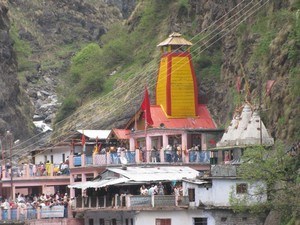
After crossing the pass, the route is generally downhill through the meadows and open forests to the Yamunotri shrine.
Day 8: Yamunotri to Janki Chatti to Hanuman Chatti - 10 km (6-7 Hours)
After Yamunotri, the trek is fairly downhill to Janki Chatti then further to Hanuman Chatti.