-
Tours
-
-
- Domestic Tours
-
-
- Resorts
- Car Rentals
- Destinations
- Getaways
- Hotels
- Tools
- * Workation
- * Tour Plans
- Blog
- List Property
- * Offers *

At a distance of 3 km from Kedarnath, Chorabari Tal, also known as Gandhi Tal, is a beautiful lake produced from the Chorabari Bamak glacier.
Chorabari Tal is a small lake that holds crystal clear water. Perched at an altitude of 3,900 m above sea level, Gandhi Sarovar lies on the foot of Kedarnath and Kirthi Stambh peak. It offers magnificent views of the surrounding Himalayan peaks.
The original name of the lake is Kanti Sarovar. In the year 1948, some of Mahatma Gandhi's ashes were immersed here, after which it was renamed Gandhi Sarovar. According to mythology, this lake was the place where Lord Shiva imparted the knowledge of Yoga to the Saptrishis. There is a Bhairava Temple close to the glacier adjacent to a cliff known as Bhairava Jhamp. The cliff was a place where devotees jumped off, believing that it would bring them mukti. The practice was banned by the British administration in the 19th century.
The lake demands a trek of 3 km and is visited in summer. It is advised to visit Gandhi Sarovar early in the morning, because the weather of this region changes rapidly. The 3 km trek commences from the iron bridge of Kedarnath and ends up at Gandhi Sarovar. The trek is easy and beautiful through grassy fields. There is a beautiful Madhu Ganga waterfall enroute to this lake.

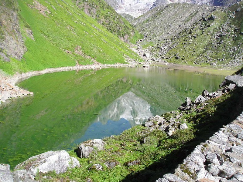
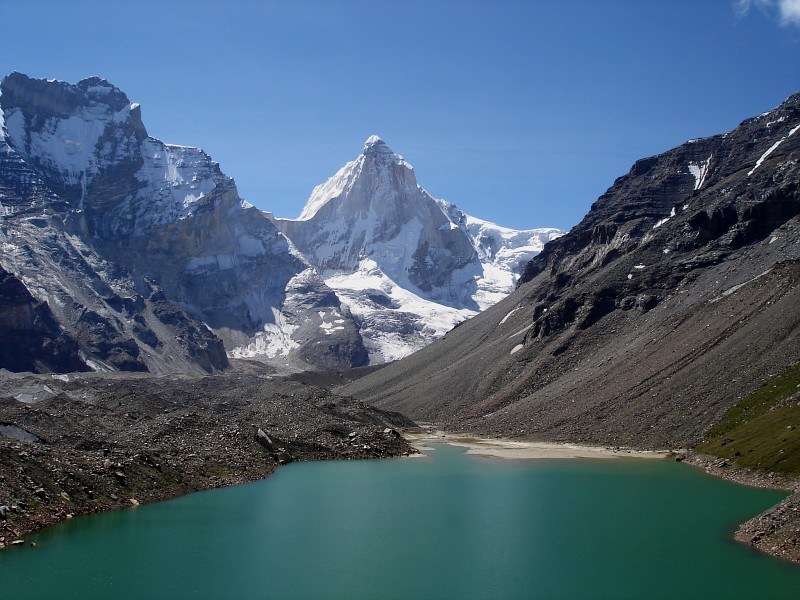
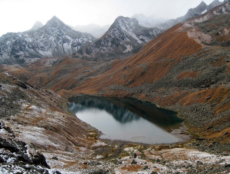
At a distance of 30 km from Badrinath and 25 km from Mana, Satopanth is a mountain lake situated close to Swargarohini Peak in the Chamoli district of Uttarakhand. It is situated at an altitude of 4,600 m (15,100 feet) in Garhwal Himalayas. It is one of the well known destination for trekking in Uttarakhand.
Satopanth is a triangular lake with three corners spread within the circumference of about a kilometer. The lake is surrounded by snow covered peaks and is named after the Hindu gods Mahesh, Vishnu and Brahma. It is believed that the divine Trinity of Brahma, Vishnu and Mahesh had meditated here and each corner of the triangular lake is named after them.
The lake is considered to be of religious significance to the local people. There is a saint known as Moni Baba, who stopped talking several years ago. There is a common belief that he can live only on sun and air, if food is unavailable. Also some unique birds are found here, which pick up the pollutants of the lake and thus keep the lake clean. The local belief is that these birds are Gandharvas who guard the lake against evils. The lake can be reached by trek crossing Lakshmivan and Chakratirtha. It is said that goddess Lakshmi and her husband Narayan meditated in Lakshmivan and Chakratirtha respectively and while meditating Narayan kept his famous Sudarshan Chakra on the valley which depressed by the weight of that Chakra to form a beautiful round shaped meadow surrounded by lofty mountains.
Satopanth ...
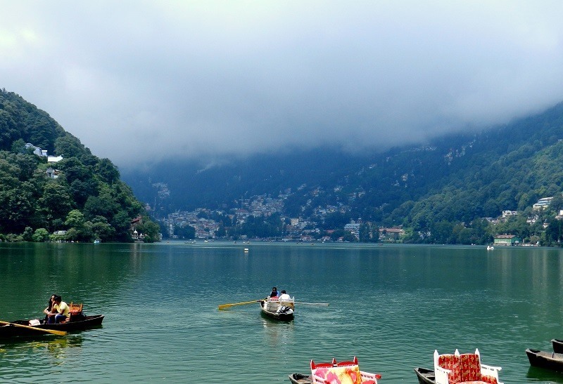
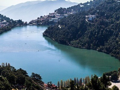
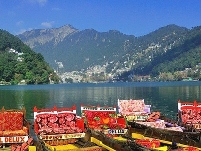
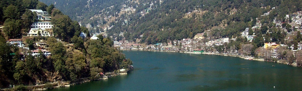
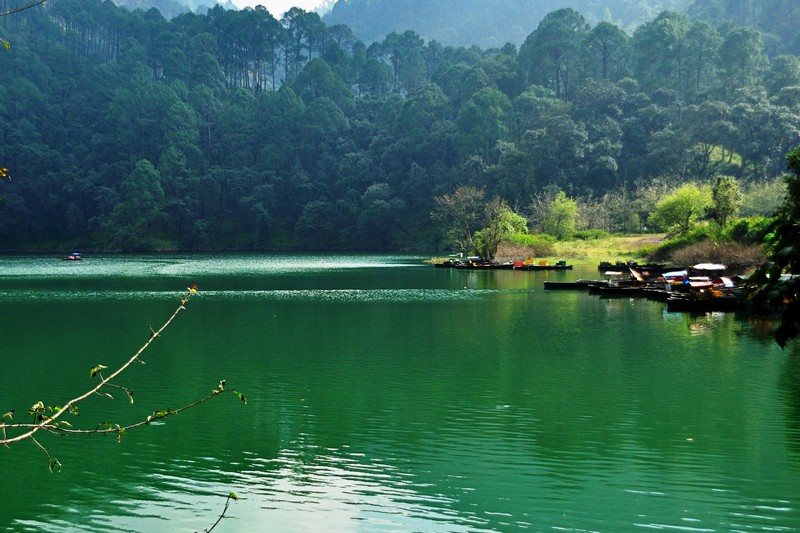
At a distance of 1.5 km from Tallital Bus Stand, Nainital Lake is a natural freshwater lake, situated amidst the main town of Nainital. It is one of the prime Nainital tourist places.
Nainital Lake is commonly represented to promote Nainital Tourism. The lake was built in 1839 by P. Barron. Situated at an altitude of 2,000 m, this is one of the four lakes of Kumaon hills, the other three lakes are Sattal Lake, Bhimtal Lake, and Naukuchiyatal Lake. Nainital Lake is lunar-shaped and has an outlet at the southeastern end. The lake covers a perimeter of 2 miles with a depth that varies from 6 m to 28 m. The northern part of the lake is called Mallital while the southern part is known as Tallital. Balia Nala is the main feeder stream of the lake. Other than this, 26 major drains, including the three perennial ones, feed it. It is surrounded by panoramic hills on three sides.
According to a legend, three sages Atri, Pulastiya, and Pulha had come here for pilgrimage; they felt thirsty and could not find any water. They dug a deep hole where the present lake stands and filled with water brought from Mansarovar Lake in Tibet. This lake is also mentioned in Skand Purana as Trishul Sarover.
This captivating lake is one of the must-visit places as part of Nainital packages. The Nainital Boat Club provides boating and yachting facilities. ...
At a distance of 22 km from Nainital & 12 km from Bhimtal, Sattal or Sat Tal is a cluster of seven inter-connected freshwater lakes located in Nainital district. At an altitude of 1,370 m, it is one of the most scenic places around Nainital and also one of the popular Uttarakhand tourist places.
The group of lakes is set amidst dense forests of oak and pine trees. Sattal is one of the few unspoiled and unpolluted fresh water bodies in India. This is often compared with Westmoreland of England by British. The names of the seven lakes of Sattal are Purna Tal, Ram Tal, Sita Tal, Laxman Tal, Nal Damyanti Tal, Sukh Tal and Garud Tal. The Garud Tal is a solitary lake and is not interconnected. The Ram, Sita and Lakshman Tal all together form the Sattal main Lake.
These lakes are heaven for migratory birds. It has 500 species of resident and migratory birds, 20 species of mammals, over 525 species of butterflies and over 11,000 species of moths, beetles, bugs and other insects. Birds like red-billed blue magpie, kingfishers, blue-throated and brown-headed barbets are easily spotted. These birds try to escape the harsh cold of the great Himalayan region by migrating to lower areas of the Himalayas. The market and tourist activities of Sattal are located around the main Sattal Lake.
Visitors ...
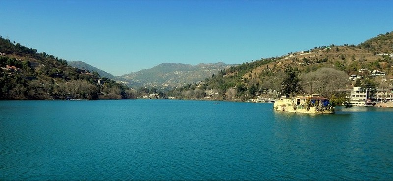
At a distance of 11 km from Sattal, and 20 km from Nainital, Bhimtal is a picturesque lake located in the town of Bhimtal near Nainital. Situated at an altitude of 1,370 m, it is one of the picturesque lakes in the Kumaon region, and among the most prominent places of sightseeing in Nainital.
The town of Bhimtal is older than the Nainital city and it was once part of the ancient silk route. The town and the lake are named after Bhima, one of the Pandavas of the epic Mahabharata who is said to have visited the place during the exile period. This is another popular attraction not to miss in a Nainital tour packages.
Bhimtal is the largest lake in the Kumaon region and is situated amidst lush green mountains. The lake is 1701 m in length, 451 m in width, and a depth of 18 m. It is spread across 63.25 hectares of area. The Victoria dam was built on this Lake in 1883 when the Kumaon region was under the British Raj. Bhimtal offers splendid views and visual vistas of nature's beauty. The lake provides a drinking water supply and supports aquaculture with several species of fish.
The Bhimtal Lake is much cleaner and less crowded than the Lake at Nainital. There is an island at the center of the lake which can be reached by boat. This island has an aquarium with different species of fish from China, South Africa, and Mexico. Earlier ...
At a distance of 17 km from Gangotri, Kedartal, also known as Shiva's Lake, is a glacial lake situated in Uttarkashi district of Uttarakhand. It is one of the highest lakes in Uttarakhand, situated at an astounding altitude of 4,912 m. It is also one of the beautiful trekking routes in Uttarakhand.
The picturesque Kedartal is situated at the base of the Thalay Sagar and Bhrigupanth Peak. The lake is fed by the water from snow over Thalay Sagar (6,904 m), Meru (6,672 m) and Bhrigupanth (6,772m), and is the source of Kedar Ganga, an important tributary of Bhagirathi River, considered as Lord Shiva's contribution to Bhagirathi River.
Kedartal is a popular trekking destination and the trek commences from Gangotri. The Kedartal trek, being one of the moderate treks in the Garhwal Himalayan region, is recommended for trekkers having prior trekking experience. The route involves a steep rocky climb along the narrow Kedar Ganga gorge en route to Bhoj Kharak, which is 8 km from Gangotri. Kedar Kharak is the next available camping site, which is 4 km from Bhoj Kharak. From here one need to trek 5 km to reach Kedartal. This 17 km trek usually takes 3-4 days to complete. The camping points of the trek are Bhoj Kharak, Kedar Kharak and Kedartal. The route passes through scenic Himalayan forests.
Kedartal is an immaculate lake holding crystal clear water and the view of the reflections of Thalay Sagar peak is truly enchanting. It is surrounded by Thalay Sagar, Bhrigupanth, ...
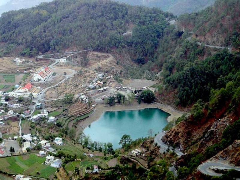
At a distance of 25 km from Nainital and 6 km from Bhimtal, Naukuchiatal is a picturesque lake situated in Nainital district. It is situated at an altitude of 1,220 m and it literally means nine cornered lake.
The lake is 175 feet deep and is the deepest lake in the Nanitaal region. It is surrounded by thick vegetation of trees and shrubs. The length of lake is 983 m and breadth is 693 m. The lake is fed by an underground perennial spring.
According to mythology, any person who can spot all the nine corners of the lake standing on the ground is guaranteed nirvana. It is believed that the lake was created by Lord Brahma and a small temple dedicated to Brahma exists near the KMVN guesthouse. It is also said that anyone who performs a circumambulation of the lake will be blessed by Lord Brahma.
This place is famous for the mesmerizing beauty of terrain and green landscapes. A walk through the woods, which offers scenic views of the lake, is a popular activity for locals and tourists. Naukuchaital has wide variety of wildlife, birds and captivating collection of butterflies. This is also a favorite spot for adventure seekers providing ample opportunity for adventure activities such as angling, trekking, paragliding, paddling and river rafting.
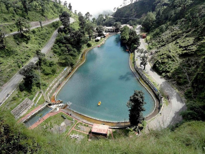
At a distance of 8 km from Tallital Bus Stand, Sariyatal is a small but beautiful lake located on Kaladungi Road in Nainital.
Sariyatal is among the numerous lakes of Kumaon range and is fed by a beautiful stream surrounded by lush green picturesque landscape. The water of the stream is very cold. This deep emerald lake is also referred as Sarita Tal.
Apart from the beautiful lake, Sariyatal is also famous for Himalayan Botanical Garden which is run by Forest Department. The Botanical Garden, spread over an area of 30 hectares, is a prominent center of study. It has a collection of several rare and endangered native plant species. This garden also has some major attractions which include an orchidarium, herbarium, Thunia Alba orchid, geodesic dome, waterfalls, etc.
Entry Ticket for Botanical Garden: Rs.20 per person.
Timings: 10 AM to 5 PM.
At a distance of 11 km from Tallital Bus Stand, Khurpa Taal is a beautiful lake located in the Khurpatal area on the outskirts of Nainital hill station. Situated on the Bajpur - Kaladgungi Road, this is one of the gorgeous lakes in Uttarakhand and among the top places to visit as part of Nainital Tour Packages.
Situated at an altitude of 1635 m, Khurpa Taal is one of the most picturesque places near Nainital. The lake is known for its pleasant climate and crystal clear water. Nestled amidst the tall trees and high hills, this emerald green lake is the best tourist place for those who wish to stay away from hustle and bustle of Nainital and want to spend some quiet moments amid nature as it is less crowded. Unexploited by tourists, the lake is a secret haven replete with bounteous nature.
Surrounded by terraced fields, the lake is also considered ideal for fishing owing to its crystal clear waters and abundance of freshwater fish. Tourists can enjoy boating on the lake along with family and friends. Undulating hills and tall trees encompass the lake on all sides and provide picture-perfect backdrops for beautiful snapshots, especially during sunrise as the lake glistens like a diamond when the rays of the sun fall on it.
Timings: 6 AM - 6 PM
Entry: Free
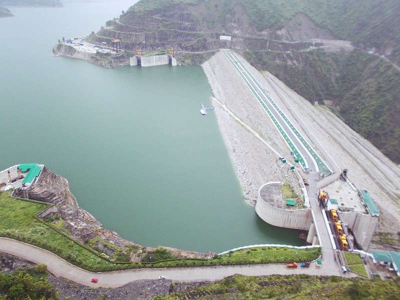
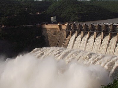
At a distance of 50 km from Dhanaulti, Tehri Dam is a multi-purpose rock and earth-fill embankment dam situated near Tehri in Uttarakhand. It is the tallest dam in India and one of the popular tourist attractions in Dhanaulti.
With a height of 260 m, Tehri Dam or Tehri Dam Reservoir is the tallest dam in India and also one of the tallest in the world. Built across Bhagirathi River, the Tehri dam was commissioned in 2006 to provide water for electricity generation, irrigation, and drinking water. It has a sediment trap efficiency of 95 % and was designed to offset 150 years of sedimentation. The length of the dam is about 575 m, crest width 20 m, and base width 1,128 m. The dam creates a reservoir of 4.0 cubic km of about 3,200,000 acre-feet, having a surface area of 52 sq. km. Provides more than 1,000 MW of hydroelectricity, it serves as the world's biggest hydro-electrical project drawing water from two great rivers of the Himalayas- Bhagirathi and Bhilangana.
The dam offers an astounding and magnificent sight with scenic views of the hills in the backdrop and clear waters in the front. This dam flocked by tourists and locals during the rainy season to get the splendid view of the overflowing water through the spillways of the dam. The dam reservoir, also known as Tehri Lake, is usually flocked with tourists interested in boating, jet skiing, water zorbing, and rafting.
Timings: 9 AM - 6 PM
Entry: Free
At a distance of 8 km from Kedarnath, Vasuki Tal or Vasuki Lake is an enchanting lake situated at an altitude of 4135 m in the beautiful hills of Kedarnath in Uttarakhand. It is also a famous place among Uttarakhand Treks.
Vasuki Tal is surrounding with very high mountains and provides beautiful view of several peaks of Himalayas. This is the lake where Lord Vishnu is believed to have bathed in ancient times. Crystal clear water flowing through the lake revealing the rock stacks inside is an amazing view in Vasuki Tal. This beautiful lake provides a charming view of the neighboring Chaukhamba peaks. There are several beautiful, colorful flowers around the Vasuki Tal and one of the famous flowers is Brahma Kamal. During winter the lake it is completely frozen.
Vasuki Tal is quite large in size and also the trekking is difficult. The total distance of Vasuki Tal trek is about 8 km from Kedarnath. The trek from Kedarnath to Vasuki Tal is a continuous ascent along a narrow track. To get to the lake one has to cross the Chaturangi Glacier and Vasuki Glacier. These glaciers are filled with ravines and crossing them demands good fitness. Trekking enthusiasts usually form a group of at least six members and start the trek. Trekking guide is must to do Vasuki Tal trek.
The best time to visit Vasuki Tal is from May to October, when the weather is mild and pleasant.
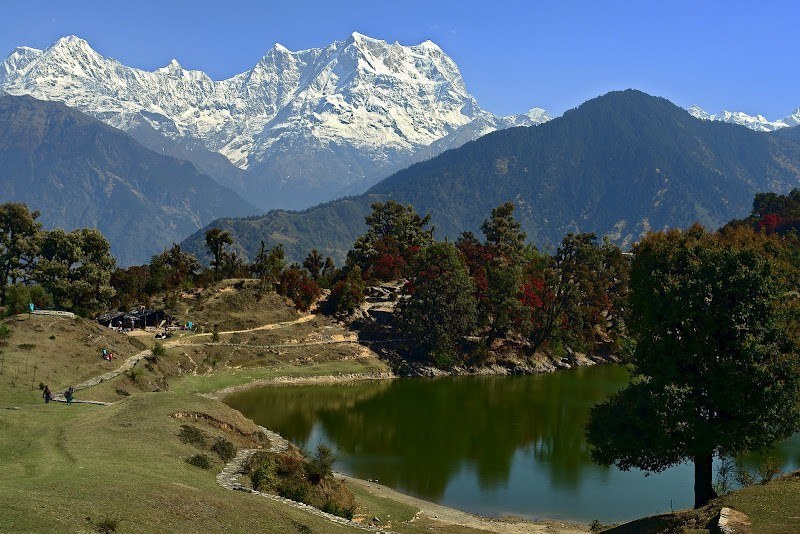
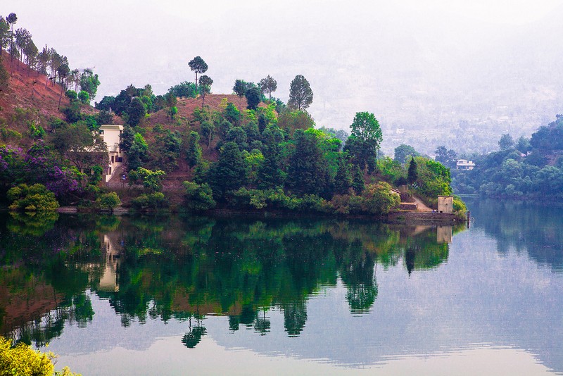
At a distance of 16 km from Ukhimath, 59 km from Gaurikund, 73 km from Kedarnath and 56 km from Rudraprayag, Deoria Tal is a beautiful mountain lake located near Saari village in Uttarakhand. It lies at an altitude of 2438 m about 3 km uphill trek from Saari on Ukhimath-Chopta road. It is a popular destination for trekking near Badrinath and also one of the top Uttarakhand places to visit for trekking.
The lake is surrounded by thick forests and the crystal clear water of this lake offers the reflection of the mighty Chaukhamba peak. It offers a splendid view of Chopta, Tungnath and Chandrashila peak to the right and the breathtaking view of mountains like Chaukhamba, Nilkantha, Bandarpunch, Kedar Range, and Kalanag to the left. It is located in the Nanda Devi Biodiversity Park and has an abundance of colorful birds and mammals.
According to the Hindu mythology, Devas used to bath in this lake hence the name. The lake is also believed to be the Indra Sarovar referred in the Puranas by wandering sages. It is also believed that it was the place from where the Pandavas were asked questions by Yaksha. Deoria Tal serves as a popular trekking destination in the region because of its ease of the trail and soothing scenic beauty. The road is motorable up to Sari, 13 km from Ukhimath and from there one has to trek about 3 km to reach the lake. Jeeps are available from Ukhimath to reach Saari. The path is well marked and passes ...
| Package | Duration | Starting Price | Details |
|---|---|---|---|
| Rishikesh - Haridwar | 4D/3N | ₹ 9950 | View Details |
| Nainital - Jim Corbett | 4D/3N | ₹ 11650 | View Details |
| Mussoorie - Rishikesh - Haridwar | 5D/4N | ₹ 13650 | View Details |
| Nainital - Almora - Ranikhet | 5D/4N | ₹ 14250 | View Details |
| Nainital - Almora - Jim Corbett | 6D/5N | ₹ 16650 | View Details |
Similar Getaways