-
Tours
-
-
- Domestic Tours
-
-
- Resorts
- Car Rentals
- Destinations
- Getaways
- Hotels
- Tools
- * Workation
- * Tour Plans
- Blog
- List Property
- * Offers *


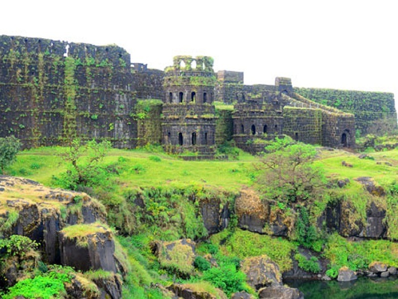
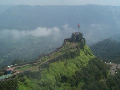
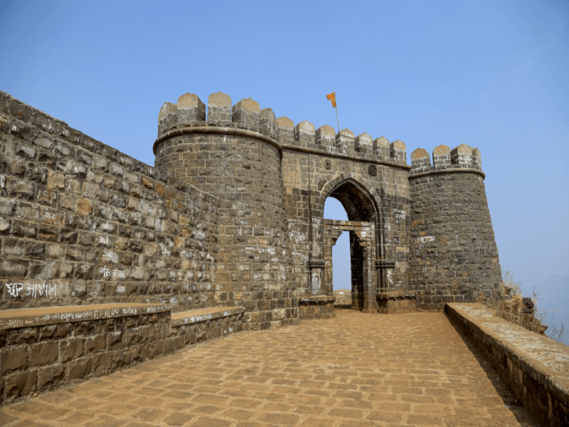
At a distance of 26 km from Mahad, 83 km from Mahabaleshwar, 105 km from Alibaug, 118 km from Lonavala, 136 km from Mumbai, 138 km from Pune and 196 km from Ratnagiri, Raigad is a hill fort situated at Pachad near Mahad in Raigad district of Maharashtra. This is one of the most popular forts in Maharashtra and popular places for trekking near Mumbai. This fort is one of the prime places to visit on a Maharashtra tour and also one of the must include historical forts in Mahabaleshwar Tour Packages as well as in Lonavala Tour Packages.
Earlier called as Rairi, Raigad was initially under the control of Chandrarao More of Jawali and was captured by Chhatrapati Shivaji Maharaj's in 1656 CE. After taking over the Rairi Fort, Shivaji Maharaj got it completely renovated and renamed it as Raigad (the King's Fort). Shivaji Maharaj made it his capital in 1674 CE when he was crowned as King. The fort was destroyed by the British in 1818 CE after they conquered it.
Perched at an altitude of 2700 feet above sea level, Raigad Fort falls under the Sahyadri Mountain range of India. The fort is constructed on an irregular wedge-shaped mass of rock and is inaccessible from three sides. The main structures inside the Raigad Fort, which today stands mostly in ruins, comprise of Queen's Quarters, Public Durbar, Watch Towers, Darwajas, etc. The Queen's Quarters consist of six chambers, ...
Distance from Kolhapur: 260 Kms
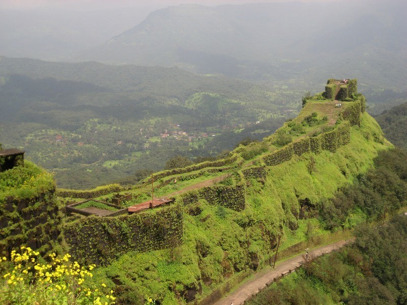
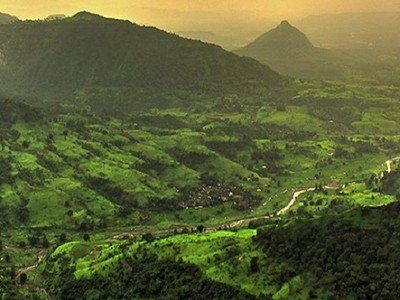
At a distance of 20 km from Mahabaleshwar, 140 km from Pune & 221 km from Mumbai, Pratapgad, also known as Pratapgarh, is a large hill fort located in the Satara district of Maharashtra. It is one of the best heritage places to visit near Mumbai, and among the popular attractions not to miss as part of Mahabaleshwar packages.
The fort lies at an altitude of 1080 m and is built on a spur that overlooks the road between the villages of Par and Kinesvar. Maratha king Shivaji Maharaj had commissioned Moropant Pingle, his prime minister, to commence the construction of this fort to defend Nira and the Koyna River banks, and also to guard the Par pass. It is one of the most scenic places to visit in Mahabaleshwar. The construction of the fortress was completed in the year 1656. The fort stands as the witness of the historic Battle of Pratapgarh between Shivaji and Afzal Khan, the commander of the Bijapur Sultanate, on 10th November 1659. In 1818, the Maratha forces had to surrender the Pratapgad Fort after losing the third Anglo-Maratha War.
After the Battle of Pratapgad, the Afzal tower was constructed outside the fort as a lookout for enemies. It is said that Afzal Khan's head is buried under the Afzal tower which is also known as Afzal Buruj. Afzal Khan's tomb is ...
Distance from Kolhapur: 207 Kms
At a distance of 80 km from Kolhapur, and 89 km from Ratnagiri, Vishalgad Fort is an ancient fort situated at Vishalgad village in Kolhapur district of Maharashtra. It is one of the historical forts in Maharashtra, and among the best places to visit near Kolhapur.
Also called Khelna or Khilna by the locals, Vishalgad Fort was one of the important forts of the Maratha empire. According to history, Vishalgad Fort was built in the year 1058 by Shilahara king Marsinh and was initially known as Khilgil. In 1209, the then king of Seuna Yadavas of Devagiri defeated Shilaharas and captured the fort. In 1309, Allauddin Khilji defeated King Ramchandra of the Seuna Yadavas of Devagiri and soon the fort was attached to the Khilji dynasty. Later, the fort was under the rule of the Vijayanagar Empire, and then the Adishlahi dynasty. In 1659, Shivaji captured the fort from Adilshah and renamed the fort 'Vishalgad' which means grand or giant fort.
In July 1660, the fort witnessed Shivaji's escape from the Adilshahi blockade around Fort Panhala and the Battle of Pawan Khind. After Shivaji's death, Chhatrapati Sambhaji would spend most of his time on the fort. He took initiative in the renovation and reconstruction of some parts of the fortresses and gates of the fort. During the times of the Maratha Empire, Vishalgad was made the capital of a large region consisting of ninety towns and villages in Kolhapur and Ratnagiri districts. In 1844, as a result of mutiny by the Killedars, ...
Distance from Kolhapur: 81 Kms
| Package | Duration | Starting Price | Details |
|---|---|---|---|
| Ellora Caves- Ajanta Caves - Aurangabad | 3D/2N | ₹ 8700 | View Details |
| Mahabaleshwar - Lonavala | 4D/3N | ₹ 12250 | View Details |
| Mahabaleshwar - Alibaug | 4D/3N | ₹ 12150 | View Details |
| Nashik - Shirdi - Ajanta - Ellora - Aurangabad | 5D/4N | ₹ 14050 | View Details |
| Mahabaleshwar - Alibaug - Lonavala | 5D/4N | ₹ 15150 | View Details |
| Best of Konkan in 6 Days | 6D/5N | ₹ 18350 | View Details |
Similar Getaways