-
Tours
-
-
- Domestic Tours
-
-
- Resorts
- Car Rentals
- Destinations
- Getaways
- Hotels
- Tools
- * Workation
- * Tour Plans
- Blog
- List Property
- * Offers *

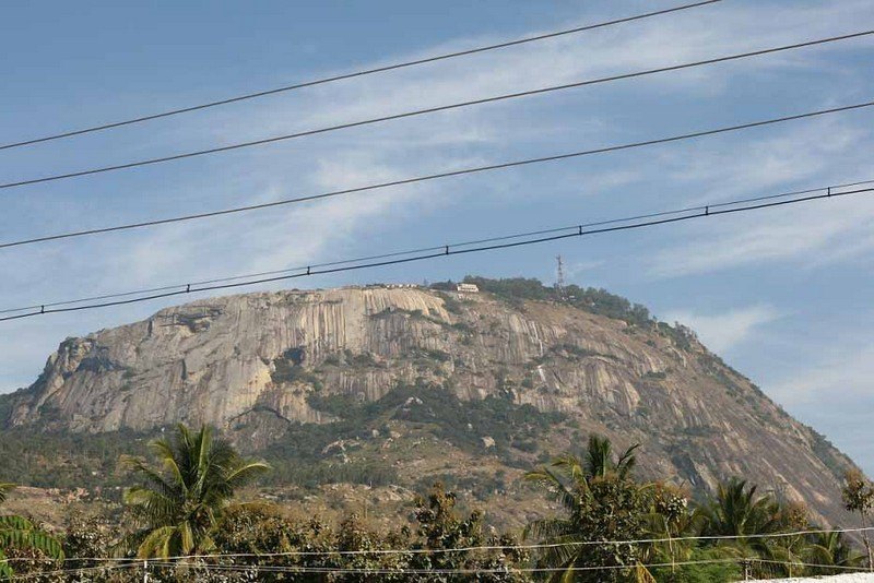
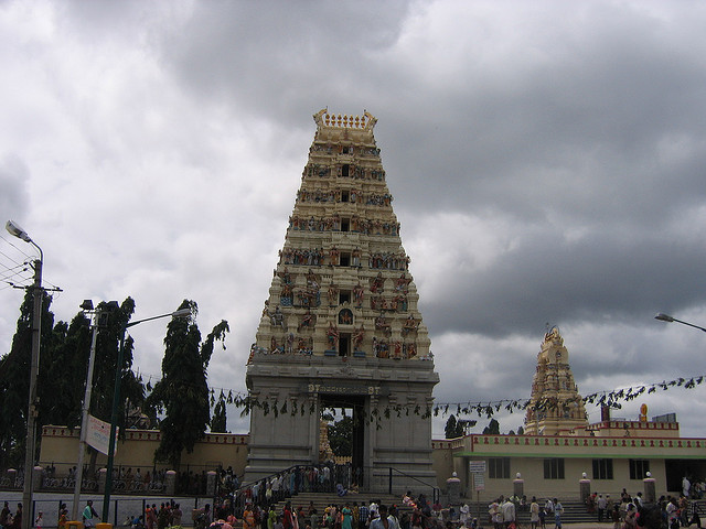
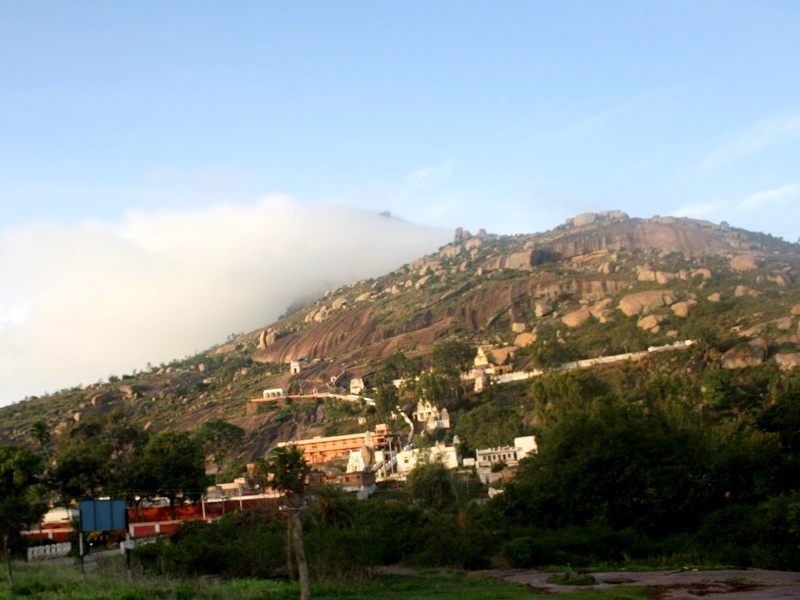
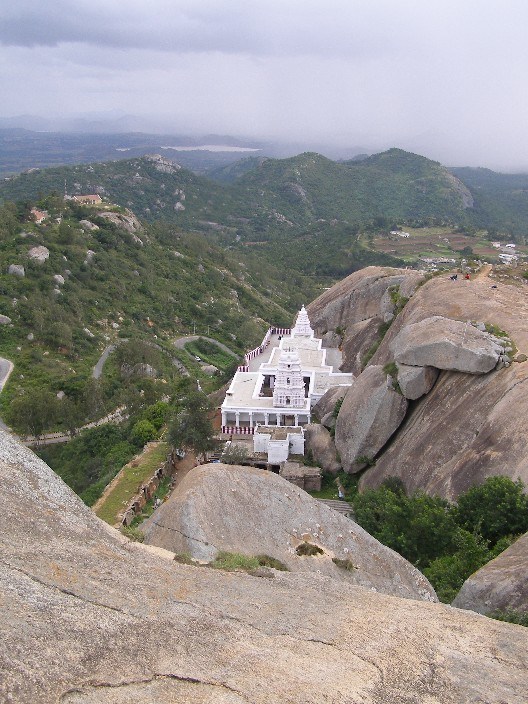
At a distance of 66 km from Nandyal, 137 km from Kurnool, 114 km from Kadapa, 348 km from Vijayawada, 350 km from Hyderabad and 407 km from Bangalore, Ahobilam or Ahobalam is an important pilgrimage center located in the Kurnool district of Andhra Pradesh. Ahobilam is one of the most famous pilgrimage sites in Andhra Pradesh and also one of the best Places to visit in Andhra Pradesh.
Ahobilam is the holy abode of Lord Narasimha, an incarnation of Lord Vishnu in man-lion form. According to legend, this is the place where Lord Narasimha killed Hiranyakasipu and saved Prahalada. Though the initial temples were built by Chalukyas in 8th century, most of the current structures were rebuilt by Vijayanagara kings around 15th century.
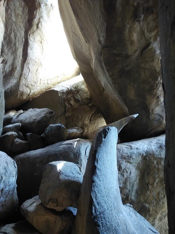
Situated amidst dense Nallamala Forest, Ahobilam is one of the 108 Divya Desams. This place is also called as Nava Narasimha Kshetra since Lord Narasimha is worshipped in 9 different forms and separate temples exist for all the forms within a radius of 5 km from the main temple. Jwala Narasimha, Ahobila Narasimha, Malola Narasimha, Kroda Narasimha, Kaaranja Narasimha, Bhargava Narasimha, Yaogananda Narasimha, Chathravata Narasimha and Paavana Narasimha are the nine forms of Lord Narasimha in Ahobilam. Few of these temples have easy access, but most of them have to be reached by difficult treks through thick forest and rocky paths.
The town is divided ...
Distance from Chennai: 372 Kms
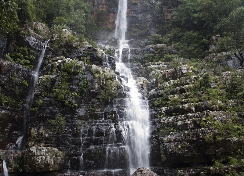
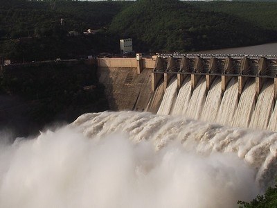
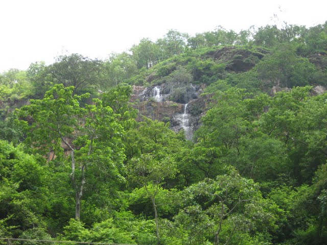
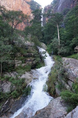
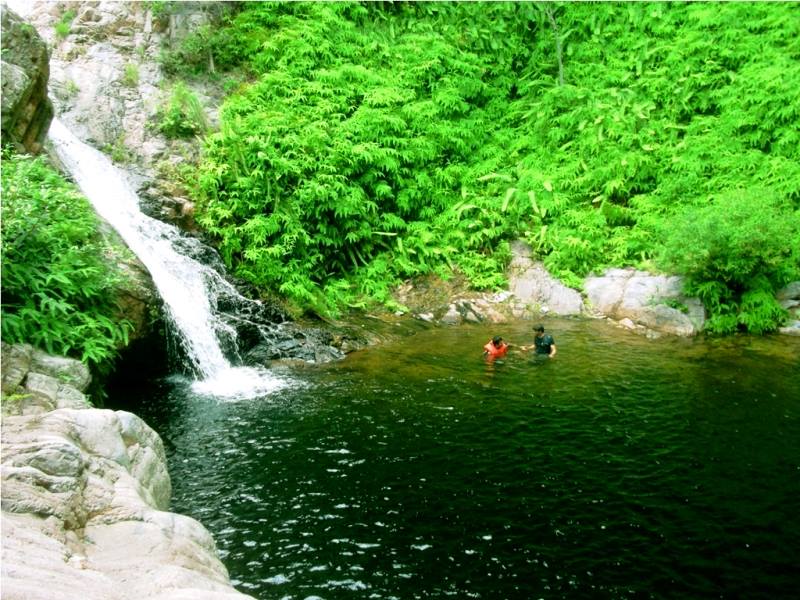
At a distance of 49 km from Bakarapet, 64 km from Tirupati, 120 km from Horsley Hills, 192 km from Chennai, 241 km from Bangalore and 89 km from Chittoor, Talakona Falls are situated in Sri Venkateswara National Park near Nerabailu Village of Yerravari Mandal of Chittoor district in Andhra Pradesh. The gorgeous waterfall falling deep into a valley from a height of around 270 feet makes it the highest waterfall in Andhra Pradesh and also one of the top Tourist places in Andhra Pradesh. It is also one of the popular waterfalls near Bangalore.
The waterfalls are placed amidst dense forest surrounded by natural beauty and greenery. It is believed that the water of Talakona Falls is enriched with herbs with healing powers. Talakona was declared as Bio-Sphere Reserve in 1990 because of wide variety of plant species present in the region. In this forest, one can find variety of endangered species like sambar, porcupine, cheetal, golden gecko, Indian giant squirrel, slender loris, panther and mouse deer etc. Talakona means 'head hill' in Telugu. This place is believed to be the starting point of Seshachalam Hills which are extended till Tirumala.
There is a 240 m long canopy rope walk, about 35 to 40 feet in height, giving a thrilling ...
Distance from Chennai: 192 Kms
Distance from Chennai: 154 Kms
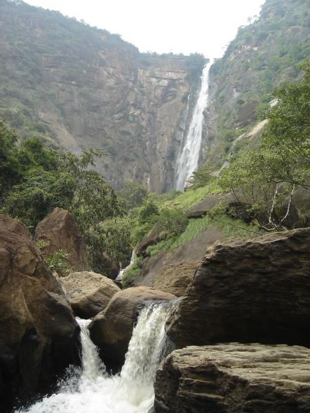
At a distance of 40 Kms from Kodaikanal & 485 Kms from Chennai, Thalaiyar Falls, also known as the Rat Tail Falls is the highest waterfalls in Tamil Nadu and third highest falls in India. It is also one of the popular sites for trekking near Kodaikanal.
With a height of 975 feet (297 meters), the falls is visible from a great distance on the ghat road towards Dindigul. This falls is considered inaccessible to the general public, as there is no access road to it. However, one can reach these falls with 6 kms trekking after 34 Kms of road journey on ghat road from kodaikanal. The trek duration is around 2-3 hours one way. The trek is considered to be of moderate difficulty.
The very edge at the top of the falls has a concrete wall. One can walk along the wall and get near the center of the falls. The water here is considered polluted and it's better to avoid bathing here.
One can catch Dindigal / Madurai buses from Kodaikanal, get down at the ghat road after 34 Kms and trek down to the falls from here. There are no sign boards but can get done at the mile stone which shows distance to Kodai as 34 km.
Distance from Chennai: 485 Kms
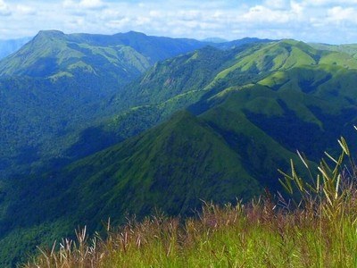
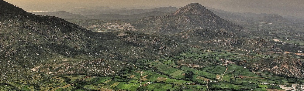
At a distance 50 km from Namakkal, 87 km from Salem, 135 km from Trichy & 395 km from Chennai, Kolli Hills or Kolli Malai is a small mountain range located in Namakkal district of Tamil Nadu. It is one of the popular places to visit near Trichy.
These hills are situated at an elevation of 1000 to 1300 m and cover an area of approximately 280 sq km. The Kolli Hills has 70 hairpin bends to reach the top of the hills from the Namakkal side. The mountains are relatively untouched by commercial tourism and still retain their natural beauty. It can be visited as a day trip as part of Tiruchirappalli tour packages.
The mountain is named Kolli Malai after the Goddess Ettukkai Amman (Kolli Paavai). According to legend, the sages chose Kolli hills when they were looking for a peaceful place to do their penance. However, the demons invaded the hills to disrupt the penance when the sages began their rituals. The sages prayed to Kollipavai, who according to the myth, chased away the demons.
Trekking at Kolli Hills is a popular activity. Trekking to Agaya Gangai Waterfalls is a wonderful experience. There are two viewpoints - one at Seekuparai and another at Selur Nadu. There is a pineapple research farm maintained by the Government of Tamil Nadu at Seekuparai Viewpoint. Kundur Nadu, Puliancholai, and Ariyur Solai are the three main reserved forests ...
Distance from Chennai: 395 Kms
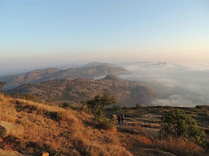
At a distance of 60 Kms from Bangalore situated close to Chikballapur, Nandi Hills or Nandidurga is a popular hill station near Bangalore. Located close to Skandagiri, Nandi hills is also one of the top trekkig destination and among the popular places to visit near Bangalore.
It gets its name from the ancient Nandi or bull which is meant to be the mount of Lord Shiva. These hills are the source of the rivers Palar, Arkavati and Pennar. It was one of the Tipu's summer retreats. There are about 1,200 steps laid from foot of the hill to reach the top of the hill. Bhoga Nandishwara Temple situated at the foot of the hills is a must see place which houses a 1000 year old sculpture of Nandi.
Tipu Sultan's Summer Palace and Tipu's Drop, a 600 ft cliff from where Tipu Sultan used to throw his prisoners, offers a spectacular view of the valley. Amrita Sarovar Lake, ruins of Tipu Sultan's fort are other places to visit. There are also three temples dedicated to Sri Ugra Narasimha, Sri Yoga Narasimha and Sri Bhoga Narasimha.
There are few accommodation options available on the peak for those who want to experience early morning sunrise, though trekking the peak early in the morning is the best option. Self camping on the peak is not safe.
Distance from Chennai: 339 Kms
Distance from Chennai: 414 Kms
At a distance of 80 kms from Bangalore & 4 kms from Kolar, Anthargange is a wonderful tourist place near Bangalore with religious significance as well as a nature & trekking destination. The place is famous for Anthargange Caves and Temple and which are quite famous as ideal places for trekking from Bangalore city, particularly well known for night treks and camping. This is one of the popular pilgrimage sites to visit around Bangalore.
Anthargange literally means Inner Spring, named after a spring originated in the hill and water flows through a bull statue at the temple in middle of the Anthargange hill. The temple is situated amidst thick vegetation and a wonderful spot to experience natural beauty of the area. Motorable road is available close to the temple but vehicles need to be parked at the entrance of the hill and need to walk up hill for about 15 minutes to reach the temple.
The temple is very ancient and considered sacred. There is a water pool formed by the water sourced from the spring. The place is full of monkeys and they also attack pilgrims for food sometimes. Visitors are advised to be careful and also take care of kids.
The Anthargange Caves are located on the peak which is about an hour trek from the temple. There are several caves on the hill top that can be explored by foot. Some of the caves are quite big and good for camping. Several visitors trek up the hill to camp overnight on the hill.
There are no food options at Anthargange. ...
Distance from Chennai: 276 Kms
At a distance of 29 km from Tada, 45 km from Srikalahasti, 85 km from Tirupati, 92 km from Chennai, 130 km from Nellore and 156 km from Chittoor, Tada falls or Ubbalamadugu Falls is situated in Varadaiahpalem mandal of Chittoor district. It is situated on the border of Tamil Nadu and Andhra Pradesh and is an ideal place for trekking near Chennai for a day trip.
The falls are located in a dense forest called Siddulaiah Kona. The falls are located within the Kambakam hills and are a popular destination for trekking, climbing and picnicking. The terrain that surrounds the falls includes rocky hill formations and lush forests interspersed with a number of streams.
To reach the falls visitors have go through the Varadaiahpalem village, about 12 km from Tada falls. There is only 7 km rugged path and the remaining distance has to be trekked through. SUVs or vehicles with high ground clearance are best suited to reach the trekking starting point. Autos can also be hired from Varadaiahpalem village to the trekking starting point. There is a forest check post on the way where visitors need to pay Rs 50 per vehicle and Rs 50 for camera. There is limited guidance in the form of arrow marks and it is advisable to hire a villager as guide in Varadaiahpalem village. The total trek distance would be about 10 km both ways, which is somewhat difficult and advisable only for physically fit people.
As soon as you enter the forest ...
Distance from Chennai: 92 Kms
At a distance of 50 Kms from Bangalore (close to NH4 towards Tumkur), Shivaganga Hill lies at an altitude of 4599 ft and it is a good short trekking destination near Bangalore and a popular tourist place to visit near Bangalore.
There are also two Shiva temples, one very close to the foot of the hill, called Shivaganga Temple and another one at top of the hill, called Gavi Gangadhareshwara Temple. The unique feature of the hill is that it looks like a bull from the East, a Ganesha from the West, a Linga from the South and a cobra from the North. A set of well laid steps will lead you to the top of hill where the shrine of Gavi Gangadhareshwara Cave temple is situated. There is a ruined fort at the bottom of the hill near Shivaganga Temple.
The Gavi Gangadhareshwara temple is believed to be very ancient, built in 13th century by Hoysala's. The current structure was built during 18th century. There is a huge rock with a large Nandi statue which offers a panoramic view of the plains below the hill.
There is a fresh water spring called Pathala Ganga on the way to hilltop past Gavi Gangadhareshwara temple. The water here is considered to be as holy. The trek to hilltop takes around 30-40 minutes one way.
While driving from Bangalore, a diversion is required at Dobbaspet (before Tumkur) towards left and Shivaganga Hill is about 7 Kms from here.
Distance from Chennai: 410 Kms
At a distance of 72 Kms from Bangalore (near Tumkur), Devarayanadurga is a rocky hill situated in the midst of picturesque locality at an altitude of 3940 ft. The main attraction of Devarayanadurga is the temples of Yoga Narasimha & Bhoga Narasimha. The Bhoga Narasimha temple is located at the foothills while the Yoga Narasimha shrine is located at the top of the hill. This is one of the popular tourist places near Bangalore.
This is also an ideal place for trekking. Motorable road is available till the hill top. Many people trek the hill from the Bhoga Narasimha temple at foothill. One can driver further from Yoga Narasimha temple to the peak of the hill to capture a nice view of the valley and surrounding places.
Devarayanadurga is famous for the natural water spring called Namada Chilume which is considered as the source of Jayamangali River. There are two other springs known as Ramatirtha and Dhanushtirtha. There is a large cave nearby with figures of Rama, Sita and Lakshmana. The car festival of Sri Bhoga Narasimha Swamy is held during the month of March/April here.
Sri Lakshmi Narasimhaswamy Jayanthi, an annual celebration of Narasimha avathara day takes place here during the month of Chaitra (around May).
A diversion is required on NH4 before Tumkur at Kyathsandra to reach Devarayanadurga.
Distance from Chennai: 429 Kms
At a distance of 55 km from Bangalore City Junction and 95 km from Mysore Junction, Ramanagara is a town in Karnataka. It is also the headquarters of Ramanagara district. It is base for few good short trekking trails near Bangalore.
Ramanagara is famous for its silk market, giving it the other name of Silk town. The Ramanagara district is surrounded by seven majestic hills Shivaramagiri, Yatirajagiri, Somagiri, Krishnagiri, Revana Siddeshwara hill, Jala Siddeshwara hill and Sidilakallu hill. The town has an Agrahara on the left bank of the Arkavati with a temple of Arkeshwara built in later Vijayanagara style. The temple is said to have been renovated by Krishna raja Wodeyar III.
Ramanagara is one of the most popular trekking spots around Bangalore. The highest elevation is over 3,000 feet and the treks here are of moderate difficulties. It is home to some highly endangered species of birds such as the Long Billed Vulture and Yellow Throated Bulbul.
Another Famous hill at Ramanagara is Ramagiri hill, the shooting location of the famous film Sholay, which is about 4 km from Ramanagara. The top of the hill has an ancient Pattabhi Rama temple. The climb is not very strenuous and there are nearly 450 steps to reach this lovely temple. This is one of the most popular places for trekking in Karnataka. The Revana Siddeshwara Betta (3066 ft) Trek offers a breathtaking view of the valley. The Revana Siddeshwara Betta ...
Distance from Chennai: 389 Kms
At a distance of 61 km from Bangalore City Junction, 18 km from Doddaballapura and 6.4 km from Ghati Subramanya Temple, Makalidurga is a hill fort situated near the village of Makali in Karnataka. This is one of the top things to do in Bangalore.
Makalidurga hill is situated at an altitude of 1350 m above the sea level. It used to be granary storage of the late 1800's palegar 'Makaliraya'. Hence it is known as Makalidurga. At the foothill there is a temple dedicated to Lord Krishna. This hill is filled with date plants, lemon grass and small boulders. From the hill top it is very beautiful to see the lakes on either side, curvy roads and the railway track below this hill. The glimpse of the train from here is very exciting.
Makalidurga Trek is a moderately difficult trek. There are some directions written on the rock which provide directions for climbing. The trekking trail here is not as popular as Savandurga but the experience is still wonderful. The Fort situated atop the massive granite hill is the main attraction in Makalidurga. The fort at the summit has an old temple of Shiva with Nandi and in legend Markandeya Rishi performed penance here. The path leading to the fort comprises of rocky and uneven trails which are often traversed by trekkers from various regions.
According to the history of Makalidurga, Vijayanagara Empire where they used to conduct army exercises in this ...
Distance from Chennai: 364 Kms

At a distance of 75 km from Bangalore City Junction, 16 km from Kanakapura & 112 km from Mysore Bilikal Rangaswamy Betta is a hill near Kanakapura town. It is one of the highest hills in the area, and also one of the popular places to visit near Bangalore.
Situated at an altitude of 3780 ft, Bilikal Rangaswamy Betta is also called Bilikal Betta that means white rocks. It is one of the popular places for trekking around Bangalore. There is a temple dedicated to Lord Rangaswamy at the peak of Bilikal Betta. This temple is located underneath a huge, white-colored rock. The temple priest lives near to the temple and the only person living at the peak. Every year, pilgrims from the surrounding area climb this hill to celebrate a festival at the Rangaswamy temple at the top.
The Trekking Trail starts from Konala Doddi (which is about 58 kms from Bangalore City Junction - Bilikal Betta is 6 kms from here). Bilikal Rangaswamy Trek is a moderate one with a well marked path up till the peak. The trekking takes 2.5 hrs uphill and about 1.5 hr downhill. The trail begins with a half kilometer walk on a relatively level path, after which the forest becomes denser and the gradient of slope increases drastically. The trail constantly winds uphill at an incline and includes slightly steep stretches.
Bilikal Rangaswamy Betta belongs to the Eastern Ghats ...
Distance from Chennai: 379 Kms
At a distance of 61 km from Bangalore City Junction and 5 km from Chikballapur, Skandagiri is an ancient mountain fortress lies at an altitude of about 1350 m. It is geographically located close to Nandi HIlls. This is among the best places for trekking near Bangalore especially famous for night treks, camping and bird watching.
Skandagiri is also known as Kalavara Durga. It has an ancient dilapidated fort that belonged to a local king and was later concurred and used by Tipu Sultan. After Tipu's downfall, the fort was ignored and laid in ruins. Today one can only see parts of the fort wall in some places.
The Skandagiri trek is a moderately difficult trek. There are two routes to reach the base of the hill. One is from Chikballapur town and the other as a detour from the road that leads to Nandi Hills. The trek starts from the Papagni Temple at the foot of the hill. This steep and fantastic trek through a maze of dense shrub is highly interesting. There are six series of stonewalls protecting an abandoned ancient temple on the hilltop.
Skandagiri is more famous for night trekking. Hundreds of people gather there on Saturday and Sunday mornings to watch the sunrise. It is best climbed very early in the morning or in a full moon night. Sunrise seen from the top is breathtaking. At the top of the hill is a stretch of flat area that has a temple and few stone pillars belonging to ancient houses. This 8 km trek comprises of ascending and descending through rugged ...
Distance from Chennai: 339 Kms
At a distance of 21 km from Koratagere, 48 km from Tumkur and 106 km from Bangalore, Madhugiri is a town in Tumkur district of Karnataka. Madhugiri is famous for a hill which is the second largest monolithic rock hill in Asia after Savandurga. It lies at an altitude of 3,930 feet and is becoming a famous destination for trekking from Bangalore.
There is a fort on the slopes of the hill which derives its name Madhugiri from the Honey bee colonies that were abundant during those days. Antaralada Bagilu, Diddibagilu, and Mysore Gate are the three gateways of the fort. A series of doorways lead to the hilltop. There is a temple of Gopalakrishna at the top of the hill. Both the temple and the fort stand in a ruined condition today due to lack of maintenance.
The construction of original mud fort was started around 1678 during the reign of Raja Heera Gowda and was finally completed around 1740 AD. Further fortification was carried out by Hyder Ali, who added huge arches, watch towers and large circular granaries. It was under the control of the British for a short duration. It was used by the British to jail the mutineers of the first India's Independence struggle in 1857.
There are four levels from the bottom to top and each level has a wall with circular bastions. The walls are about 6 feet tall with slits at regular intervals. Throughout the climb to the fort there are huge tanks used for the storage of rain water. The trek to Madhugiri is of moderate to difficult ...
Distance from Chennai: 463 Kms
At a distance of 16 km from Nagalapuram town, 44 km from Puttur, 87 km from Chennai, 78 km from Tirupati, 107 km from Chittoor, 130 km from Vellore, 120 km from Kanipakam & 288 km from Bangalore, Nagalapuram is a small historical town located in the Chittoor District of Andhra Pradesh. Nagalapuram is famous for two things, one is Sri Vedanarayana Swamy Temple and the other one is Nagalapuram falls trekking (also known as Saddhi Koodu Madugu). This is one of the popular sites for trekking near Chennai and also among ideal weekend getaways around Chennai for a two day trip.
Sri Vedanarayana temple is grand shrine dedicated to Lord Vishnu and is said to have been built by Krishna Devaraya of Vijayanagar Empire in remembrance of his mother Nagala Devi, after whom the town is named. The temple reflects the Vijayanagara architectural and the main deity idol is facing west. The sanctum sanctorum has Vedanarayana Swamy with his consort's Sridevi and Bhoodevi on either side. Lord Vishnu is in Matsya Avatar, the first among the Dasavatar, who saved the four Vedas from Somakudu and returned to Brahma.
The large temple complex comprises of a grand entrance, tall gopura, wide corridors and beautiful central shrine with excellent carvings. The special feature of this temple is a festival called Surya Puja, celebrated annually for 3 days during the month of March. The ...
Distance from Chennai: 87 Kms
| Package | Duration | Starting Price | Details |
|---|---|---|---|
| Hogenakkal - Yercaud | 3D/2N | ₹ 9050 | View Details |
| Kanchipuram - Mahabalipuram - Pondicherry | 4D/3N | ₹ 10750 | View Details |
| Madurai - Kanyakumari - Rameshwaram - Thanjavur | 4D/3N | ₹ 11350 | View Details |
| Chidambaram - Thanjavaur - Madurai - Rameshwaram - Trichy | 5D/4N | ₹ 14700 | View Details |
| Thanjavur - Madurai - Rameswaram - Trichy - Mahabalipuram | 6D/5N | ₹ 16850 | View Details |
| Best of Tamilnadu in 8 Days | 8D/7N | ₹ 22750 | View Details |
Similar Getaways