Mayali Pass Trek, Kedarnath - Timings, Trekking, Camping, Best Time to Visit


 #8 of 18 Places to Visit in Kedarnath
 Distance (From Kedarnath): 15 Kms
 Trip Duration (Including Travel): 10 Full Days
 Place Location: 61 Km From Ghuttu Village
 Transportation Options: Bus / Cab / + Walk/Trek
 Travel Tips: None
At a distance of 61 km from Ghuttu village and 15 km from Kedarnath, Mayali Pass is situated at an elevation of 5300 m in Bhilangana Valley and it offers great views of Masar Tal and Vasuki Tal. Also the pass is famed for the spectacular view of Thalay Sagar, Kedar dome and other peaks of Gangotri region.
Mayali Pass is a famous place for trekking in Uttarakhand and is followed by many trekkers every year. In ancient time this trek was used by pilgrims to travel between Gangotri and Kedarnath. The Mayali Pass trek route starts from Ghuttu and the goes along Bhilangana valley. The Mayali Pass trek from Ghuttu to Gaurikund is of moderate difficulty. The trek offers an extraordinary experience of Himalayan peaks. The remote Indian villages of Gangi, Bhilangna River Catchment, Thalay Sagar peak, and Khatling glacier are the highlights of Mayali Pass trek.
Mayali Pass is approachable by two routes. One is from Ghuttu and the other is from Mala, a village right above Uttarkashi. The route from Mala goes through a lot of grasslands and is very beautiful, but takes two weeks. The route from Ghuttu is the shorter one and is 9-10 days trek.
The trek starts from Ghuttu and moves parallel to River Bhillangna via Reehi, Gangi, Kalyani, Kharsoli, Tambakund and then reaches Khatling Glacier, the source of River Bhilangna. Chowki, a meadow near Khatling Glacier is an amazing camping ground with great view of peaks, the most impressive being Thalay Sagar peak. From Chowki, it is a steep climb to Masartal. Further the climb becomes steeper and in snow to reach Masar Top and eventually Mayali Pass. This is followed by a steep descent to Vasuki Tal and further to Kedarnath shrine and finally the trek ends at Gaurikund.
Day 1 - Ghuttu to Reehi (10 km / 4-5 hours)
Start from Ghuttu and gently hike to Reehi -first day of camp. The trek is a gentle climb of about 10 km. Overnight stay in camps at Reehi.
Day 2 - Reehi to Gangi (12 km/ 4-5 hours)
Start from Reehi and trek to Gangi - a remote village of strong cultural heritage. The trek is mostly gentle climb of about 12 km, with slight steepness in the last few kilometers. Camp in Gangi.
Day 3 - Gangi to Kharsoli (15 km/ 6-7 hours)
Start from Gangi and go through the zigzag climb to reach Kharsoli camp site - where a Nallah confluences with Bhilangna River. Camp in Kharsoli.
Day 4 - Kharsoli to Chowki (12 km /5-6 hours)
Start from Kharsoli and reach Chowki Campsite. The total distance should be about 12 km. Visitors camp on the banks of Doodh Ganga River facing south side of Hanging Glacier known as Khatling Glacier.
Day 5 - Rest Day
Visitors can take rest and perhaps visit the Khatling Glacier, which is close to Chowki Campsite.
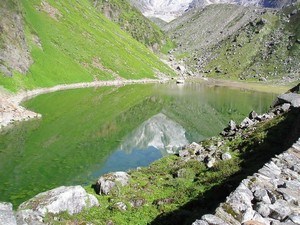
Day 6 - Chowki to Masar Tal (6.5 km/ 4-5 km)
Start from Chowki and reach Masar Tal campsite. Masar Tal is a high altitude alpine lake. Camp by the side of Masar Tal.
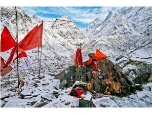
Day 7 - Masar Tal to Vasuki Tal via Mayali Pass (14 km / 7-8 hours)
On this day visitors can cross the Mayali Pass at an altitude of 5300 m. Hike through the pass is slightly technical and needs excellent guidance of an expert mountaineer. After crossing the Pass trekkers reach Vasuki Tal - another pristine lake of Garhwal Himalayas.
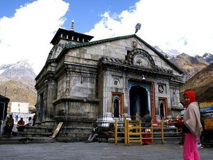
Day 8 - Vasuki Tal to Kedarnath (8 km /3-4 hours)
Start from Vasuki Tal and reach Kedarnath - the shrine of Lord Shiva.
Day 9 - Kedarnath to Gaurikund (14 km/3-4 hours)
Start from Kedarnath and reach Gaurikund - which is the road-head. Trek terminates here.
Best time to visit Mayali Pass Trek is from May to June and from September to mid-October.