Kote Betta Trek, Coorg - Timings, Trekking, Camping, Best Time to Visit


 #30 of 40 Places to Visit in Coorg
 Distance (From Coorg): 52 Kms
 Trip Duration (Including Travel): 4-6 Hours
 Place Location: Near Hattihole
 Transportation Options: + Walk/Trek
 Travel Tips: None
At a distance of 33 km from Somwarpet and 52 km from Madikeri, Kote Betta is a mountain peak in Karnataka. Located in between Somwarpet and Madikeri, it is one of the popular places for trekking in Coorg.
Situated at an altitude of 5,400 feet, Kotebetta is the third highest peak in Coorg after Tadiandamol and Brahmagiri. The word Kote Betta means Fort Hill. It has been named because of its appearance which resembles a fort. Locals believe that the famous Pandava brothers spent a significant period of their exile here. This is a classic hill and jungle trek passing through different terrains.
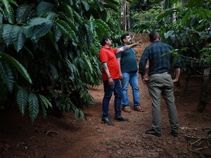
This trek of moderate difficulty begins at a point close to the Hattihole Bridge. From there, the peak is at a distance of 10 km. The trail is truly magical as it is passing through rows of coffee plantations on one side and green hills on the other. As the footsteps proceed further, the trail goes through a dense jungle and then to a wide-open plain. There is a temple dedicated to Lord Shiva at the peak of the hill. Around the temple, one can find a flat ground with ample shade to sit and enjoy the glories of the mountains overlooking the endless forests. Although one doesn't require any permission from the authorities to trek the hill, it is better to have one guide to help you throughout the trekking.
Timings: 6 AM - 6 PM